GeoServer Blog
Join the GeoServer team at FOSS4G 2019 Bucharest
The GeoServer team is excited to attend this years event, hosted August 26-30th by the Romanian OSGeo Local chapter of geo-spatial.org. We are happy to showcase a wide range of GeoServer activities and look forward to meeting you there.

Update: Bird of a feature sessions announced, GeoServer Flock and Demos Wednesday 18:00-19:30 Concerto
Workshops
Workshops August 26-27th offer one of the main reasons to attend FOSS4G -hands-on experience with open source technology. GeoServer workshops include:
- GeoTools Developer Workshop
- Getting started with GeoServer: data configuration and styling
- GeoServer Developers Workshop
The early bird price of 50 EUR is an amazing value and well worth arriving earlier in the week.
Main Conference
The Main conference August 28-30 includes a wide range of GeoServer presentations covering project updates, highlighting the best features, key technologies and examples showcasing success stories.
- Creating Stunning Maps in GeoServer, with SLD, CSS, YSLD and MBStyles
- State of GeoServer 2019
- GeoServer feature frenzy
- Mapping the world beyond Web Mercator
- Crunching Data In GeoServer : Mastering Rendering Transformations, WPS Processes And SQL Views.
- GeoServer WFS3: introduction to the RESTful, schemaless, JSON first download service
- Standing up a OSM clone with GeoServer and CSS
- State of JAI
- The secret life of open source developers
- Using the OGC Web Processing Service (WPS) to move business logic to the server
- And many more …
This year also features labs which offer a hands-on experience open to all conference participants. GeoServer is represented with:
- Becoming a Documentation Contributor
- Introduction to OGC services, with examples from GeoServer
If you would like to attend a lab be sure to arrive early, when offered at prior conference labs have proven really popular (standing room only).
Community Sprint
The week concludes with a FOSS4G Community Sprint (wiki signup). GeoServer opportunities include:
- Did you take the developer workshop? This is a great chance to make your first pull-request.
- Did you attend the Documentation Contributor Lab? Join us and put your new skills to use!
- Experienced GeoServer developers can use the wiki to organize additional topics prior to the event.
GeoServer 2.15.1 Released
| We are pleased to announce the release of GeoServer 2.15.1 with downloads (zip | war | exe), documentation (html | pdf) and extensions. |
This is a stable release recommended for production. This release is made in conjunction with GeoTools 21.1 and GeoWebCache 1.15.1. Thanks to everyone who contributed to this release.
For more information see the GeoServer 2.15.1 release notes.
Improvements and Fixes
This release includes a number of fixes and improvements, including:
- Addressed “potentially malicious String” error encountered when first establishing a session with the web administration application.
- Importer fixed to connect to and create PostGIS datastore
- Fix REST API user creation problem
- Map preview fix to display projected maps with WMS 1.3.0
- WCS 2.0.1 metadata fix for GetCapabilities and DescribeCoverage
- WCS 1.0.0 and WCS 2.0 fixes for elevation and custom dimension use
- GetFeatureInfo template can now access metadata for raster layers
- Styling improvements respecting followLine and maxAngleDelta
About GeoServer 2.15 Series
Additional information on the 2.15 series:
- Layer service settings allow WFS, WMS, WPS to be enabled on a layer by layer basis.
- GeoFence internal server extension a new approach to access control
- Style Editor supports auto-complete using control-space shortcut.
- SLD REST Service extension supports generation of thematic styles for vector and raster content.
- WPS vendor operation GetExecutation Status and Dismiss all management of running processes.
- Java 11 can now be used, see Running on Java 11.
- JAI-EXT operations are now enabled by default.
-
Release notes (2.15.1 2.15.0 2.15-RC 2.15-M0)
Java 11 comparability is the result of a successful code-sprint. Thanks to participating organizations (Boundless, GeoSolutions, GeoCat, Astun Technology, CCRi) and sprint sponsors (Gaia3D, atol, osgeo:uk, Astun Technology).
GeoServer 2.14.3 Released
| We are happy to announce the release of GeoServer 2.14.3. Downloads are provided (zip | war | exe) along with docs (html | pdf) and extensions. |
This is a maintenance release of the GeoServer 2.14 series and is recommended for all production systems. Users of prior releases of GeoServer are encouraged to upgrade.
This release is made in conjunction with GeoTools 20.3 and GeoWebCache 1.14.3. Thanks to all who contributed to this release.
| For more information please see our release notes (2.14.3 | 2.14.2 | 2.14.1 | 2.14.0 | 2.14-RC). |
Improvements and Fixes
This release includes a number of new features and improvements, including:
-
Fix user creation failing on REST API
-
OpenLayers 3 preview did not work on projected data when using version 1.3 of the WMS protocol
-
Fixed style editor HTML issues when going back from full screen editor mode, and fixed moving styles referring to local icons from global to workspace
-
NetCDF extension packaging fix, allows it to run without also having the NetCDF out plugin installed
-
Assorted fixes in WMTS workspace specific capabilities document generation
About GeoServer 2.14 Series
Additional information on the GeoServer 2.14 series:
-
New MongoDB extension added
-
Style editor improvements including side by side editing
-
Nearest match support for WMS dimension handling
-
Upgrade notes documenting REST API feature type definition change
-
State of GeoServer 2.14 (SlideShare)
-
GeoServer Ecosystem (SlideShare)
-
GeoServer Developers Workshop (SlideShare)
GeoServer 2.15.0 Released
| The GeoServer team is happy to announce the GeoServer 2.15.0 release with downloads (zip | war | exe), documentation (html | pdf) and extensions. |
This release is production ready and is ready to work with your Java 8 or Java 11 operational environment. This release is made in conjunction with GeoWebCache 1.15.0 and GeoTools 21.0.
The ability to work with Java 11 is the result a dedicated code sprint. Thanks to organizations participating in the code sprint (Boundless, GeoSolutions, GeoCat, Astun Technology, CCRi) along with sprint sponsors (Gaia3D, atol, osgeo:uk, Astun Technology).
Layer Service Settings
To start things off an often requested capability, the ability to control which services are enabled on a layer-by layer basis.
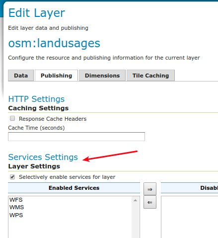
To try it our yourself see Service Settings in our user manual.
GeoFence Internal Server Extension
Originally a standalone service offering fine grain control over GeoServer security this functionality has been packaged up and embedded into a GeoServer extension for easier deployment.
-
GeoFence rules provided greater control over security allowing layer by layer service restrictions
-
GeoFence rules can provide access to data overriding layer details including CQL filter to limit contents returned and default style used for rendering
-
GeoFence rules can limit access to a geographic extent
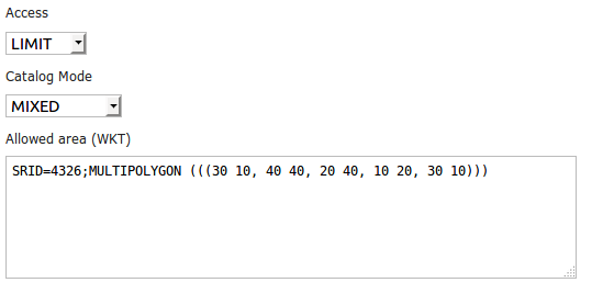
For more details see GeoFence Internal Server in our user manual.
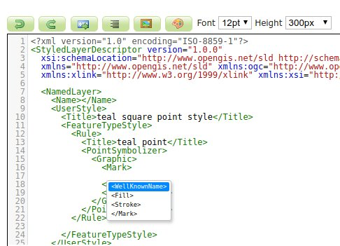
Style Editor SLD Auto-Complete
To help make editing easier the Style Editor can provide auto-complete suggestions for SLD 1.0. To try it out yourself use control-space for context aware suggestions.
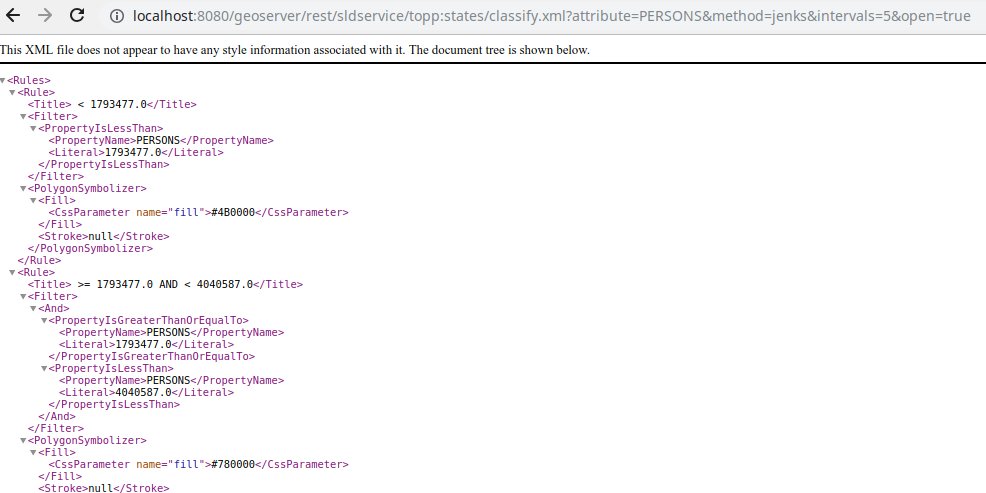
Generate Classified Thematics maps
SLDService is now an official extension, with a number of improvements. SLDService can now be used for the
-
classification of raster data too
-
equal area classification
-
standard deviation filtering
The SLD REST Service extension is used to generate thematic styles based on attribute data:
curl -v -u admin:geoserver -XGET
  http://localhost:8080/geoserver/rest/sldservice/states/classify.xml
  ?attribute=PERSONS
  &ramp=CUSTOM
  &method=quantile
  &intervals=3
  &startColor=0xFF0000
  &endColor=0x0000FF
  &open=true
For more information see SLD Rest Service in our user manual.
WPS GetExecutionStatus and Dismiss Operations
WPS “GetExecutions” vendor operation allows each user to get the list of running processes:
-
Users can review all their running processes
-
Administrators can see all processes
The Dismiss vendor operation can be used to cancel the execution of one of the listed processes.
For more information see Dismiss in our user guide.
Java 11 Support
The provided binary download works with either Java 8 or Java 11. Tomcat 9 or newer is required for the WAR install. The user guide compatibility list will continue to be updated based on your feedback.
The java ecosystem is now being led by the open source OpenJDK project, with long term support available from a range of organizations notably RedHat OpenJDK and Adopt OpenJDK. The GeoTools user guide provides an overview of Java 8 and Java 11 distributions.
The net effect of these changes:
-
If you have been using Oracle JDK please review your options
-
Java 8 will continue to be available
-
The Java ecosystem is now led by the open-source Open JDK project
Java 11 no longer supports the Java 2 extension mechanism used for native JAI and native ImageIO libraries. We recommend the use of the pure Java JAI-EXT operations which have been made the default (see the next section).
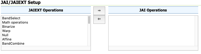
JAI-EXT operations on by default
The use of the JAI-EXT operations have long been a recommendation, with this release we are making them the default for GeoServer. The JAI-EXT library offers a pure java implementation enhanced for geospatial functionality supporting NODATA pixels and support for vector footprints.
GeoServer Codebase
In addition to Java 11 support this release includes:
-
Add JSON as a Legend Output format (GISP 173)
-
Printing plugin upgrade version of JTS
-
Upgrade NetCDF dependencies
-
Improvements for vector tile production, both in terms of output correctness and production performance
Thanks to Andrea Aime for steady work on the codebase quality:
-
PMD source code analysis, high priority checks, will fail the build in case of issues
-
Error Prone byte code analysis, same as above
-
Many small bugs fixed
For more details developers are invited to review Automated Quality Assurance checks in our developers manual. Also, work in ongoing on the master (dev) branch to extend the reach of static code checks using SpotBugs and CheckStyle too.
About GeoServer 2.15 Series
Additional information on the GeoServer 2.15 series:
-
Release Notes (2.15.0 2.15-RC 2.15-M0) - Running on Java 11 (User Manual)
GeoServer 2.15-RC Released
| We are happy to share a GeoServer 2.15-RC milestone release with downloads (zip | war | exe), documentation (html | pdf) and extensions. |
This release candidate is provided for everyone considering a Java 11 operational environment in 2019. A release candidate provides a final to support the development team with early feedback: your assistance and participation is requested!
This release is a result of participation in the OSGeo Java 2018 Code Sprint and is made in conjunction with GeoTools 21-RC and GeoWebCache 1.15-RC. We would like to thank organizations participating in the code sprint (Boundless, GeoSolutions, GeoCat, Astun Technology, CCRi) along with sprint sponsors (Gaia3D, atol, osgeo:uk, Astun Technology). Our gratitude goes out to the individuals who worked so hard to bring everything together.
Highlights
In addition to Java 11 support this release includes:
-
JAI-EXT enabled by default, in other words, support for NODATA pixels on by default
-
Add JSON as a Legend Output format (GISP 173)
-
Printing plugin upgrade version of JTS
-
SLDService become an official extension, with a number of improvements in it SLDService (classification of raster data too, equal area classification, standard deviation filtering)
-
Allow configuring services on a per layer basis
-
GeoFence upgraded from community module to official extension
-
WPS “GetExecutions” vendor operation allows each user to get the list of running processes (limited to his account for normal users, showing all processes if the request is made by an admin)
-
Autocomplete support for SLD 1.0 in style editor
-
Improvements for vector tile production, both in terms of output correctness and production performance
-
Upgrade NetCDF dependencies
-
QA work adding PMD and ErrorProne checks in the build
-
and a large number of bug fixes.
Java 11 Support
The provided binary download works with either Java 8 or Java 11. Tomcat 9 or newer is required for the WAR install.
We will the update the user guide compatibility list based on your feedback and testing of this 2.15-RC milestone release. Please note that Java 11 no longer supports the Java 2 extension mechanism used for native JAI and native ImageIO.
This is a good opportunity to review your operational environment and help test GeoServer with the environment you intend to use in 2019.
Java Roadmap Considerations
Our initial concerns with respect to continued availability of the Java 8 platform have been alleviated by industry action and commitment. Extensive Java 8 support options are now available, with RedHat making a public commitment to contribute fixes to the OpenJDK 8 codebase, and a range of organizations committed to making OpenJDK 8 builds available on a range of platforms.
Oracle has changed to a six month release schedule, donating additional components to OpenJDK to make it lead platform. Long term support (beyond six months) is being offered from a range of organizations notably RedHat OpenJDK and Adopt OpenJDK.
The net effect of these changes:
-
If you have been using Oracle JDK up until now it is time to review your options
-
Java 8 will continue to be available
-
The Java ecosystem is now led by the open-source Open JDK project
See the GeoTools user guide for a table outlining the Java 8 and Java 11 alternatives to consider in the year ahead.
About GeoServer 2.15 Series
Additional information on the GeoServer 2.15 series:
-
Release Notes (2.15-RC)
-
Release Notes (2.15-M0)
-
Running on Java 11 (User Manual)
Tutorials
- How to style layers using GeoServer and QGIS
- How to Publish a GeoTIFF file in GeoServer
- A Comprehensive Guide to Publishing a Shapefile in GeoServer
- GeoServer About & Status - A Practical Guide
- GeoServer installation methods on Windows
- Introducing GeoSpatial Techno with a Video Tutorial
- GeoServer Presentations on FOSS4G 2019