GeoServer Blog
GeoServer 2.6.1 released
The GeoServer team is happy to announce the release of GeoServer 2.6.1. Download bundles are provided (zip, war, dmg and exe) along with documentation and extensions.
GeoServer 2.6.1 is the next the stable release of GeoServer and is recommended for production deployment. Thanks to everyone taking part, submitting fixes and new functionality:
-
Fix for slow rendering of maps with lots of layers coming from a spatial database, reported by numerous users
-
Improvements in rendering labels over transparent maps
-
Fix for rendering tiled raster data, it could occasionally miss portions of the data
-
Fixes for WFS 2.0 joins
-
Better memory management when HTTP gzip-ping large amounts of GML/CSV/JSON data
-
Multidimensional WCS 2.0 outputs (NetCDF downloads) now support subsetting in CRS other than WGS84
-
An option to disable JAI native warp, which can cause some instability when reprojecting certain raster data sets
-
Some improvements in the GeoPackage outputs (still a community module, available via nightly builds)
-
Check the release notes for more details
-
This release is made in conjunction with GeoTools 12.1
Thanks to Andrea (GeoSolutions) for this release
About GeoServer 2.6
Articles and resources for GeoServer 2.6 series:
-
Raster Views in GeoServer via the CoverageView concept (GeoSolutions)
-
Advanced Raster Projection in GeoServer (GeoSolutions)
-
Supporting Wind Barbs In GeoServer and GeoTools (GeoSolutions)
-
GeoServer now supports Vector Footprints for ImageMosaic (GeoSolutions)
GeoServer 2.5.3 released
The GeoServer team is happy to announce the release of GeoServer 2.5.3. Download bundles are provided (zip, war, dmg and exe) along with documentation and extensions.
GeoServer 2.5.3 is the next the stable release of GeoServer and is recommended for production deployment. Thanks to everyone taking part, submitting fixes and new functionality:
-
A new process, PagedUnique, to efficiently grab large amounts of unique values from a layer column
-
Legend preview functionality in the style editor
-
A long awaited fix for poor font rendering when creating transparent map
-
Some fixes in WFS 2.0 joins
-
GeoJSON CRS syntax has been updated to the current valid one (we were using a old legacy one)
-
Some GetFeatureInfo further fixes for complex styles
-
Fix scale computation when the CRS unit of measure is not meters
-
Some WMS 1.3 rendering fixes with image mosaics
-
Avoid invalid reports of leaked connections when using SHAPE-ZIP output format against SQL views whose SQL is no more valid
-
Check the release notes for more details
-
This release is made in conjunction with GeoTools 11.3
About GeoServer 2.5
Articles and resources for GeoServer 2.5 series:
-
GeoServer 2.5-beta announcement reviews key features of this release:
-
WCS 2.0 and WCS 2.0 Earth Observation have been added (thanks to DLR and Eumesat for funding this)
-
The addition of a batch importer to making setting up GeoServer easier (thanks to MapStory).
-
High performance PNG encoder based on PNGJ library (Andrea Aime). Improved JPEG performance using libjpegturbo available as an optional extension (Simone Giannecchini and Daniele Romagnoli)
-
Use of ST_Simplify to improve PostGIS rendering performance (a collaboration with Andrea and Jonathan Moules).
-
New implementation of GetFeatureInfo that takes into account symbol shapes, offsets, and dynamic line widths into account (thanks to Eskilstuna municipality for funding this).
-
-
Using GeoServer at IGN to create new digital maps is an impressive look at advanced styling deployed by the french mapping agency
-
Labelling a MultiPoint geometry with WPS (Boundless) is a good example of integrating WPS and Styling
-
Achieving extreme GeoServer Scalability with new Marlin vector rasterizer (GeoSolutions) shows an exciting JRE extension that can be used for improved performance. If you are using GeoServer with a large number of CPU cores you owe yourself an hour to try this out.
-
DXF output format promoted to official extension for GeoServer (GeoSolutions)
-
Active Directory based security in GeoServer through LDAP (GeoSolutions)
GeoServer 2.6.0 Released
The GeoServer team is pleased to account the greatly anticipated 2.6.0 release. This release is now available for download with zip, war, dmg and exe bundles available (see the change log for details on last minute fixes).
Thanks to the user list for testing the 2.6-beta and 2.6-RC1, this collaboration and testing really helped smooth our migration to Java 7. The Code Sprint at FOSS4G was able to fill in gaps testing oracle curve support, the marlin extension on a range of platforms, and providing documentation introducing wind barbs and inline custom marks.
Thanks to Ian Turton, Jody Garnett and Kevin Smith for assisting in this release. This release is made in conjunction with GeoTools 12.0.
Java 7
Ensure you are using Oracle o OpenJDK Java 7.
Support for Java 7 is not only a new feature for GeoServer 2.6.0 - Java 7 is a requirement.
The installation instructions have been updated for windows, mac and linux users. Mac users will have an easy upgrade as GeoServer.app includes an appropriate Java 7 virtual machine.
New and Improved
New functionality:
-
**WFS Cascade: **WFS Cascade has been updated to use a brand new GeoTools wfs client implementation.
-
Curve support for GML and WMS: GeoServer curve support has been added for interaction with Oracle Spatial. To configure look for Linearization tolerance when configuring your layer. As outlined in the FOSS4G presentation we are seeking interested parties to implement or fund curve support for PostGIS and SQL Server.
-
Advanced Projection Handling: Considerable care has been taken in the handling of raster data across the dateline and in polar projections.
-
**Coverage Views: **recombine bands from different sources into a multi-band coverage (use “configure new coverage view” when creating a new layer).

-
Vector footprints support in image mosaics: you can now cut out of your images the “bad” parts using vector footprints, setup as sidecar wkb/wkt files, or as a global footprints shapefile
-
**Pluggable Styles: **this change allows greater integration with the CSS Extension (and opens the door for even more style languages in the future)
-
Wind Barbs and WKT Graphics: for greater creative control.
-
**Printing: **new implementation from our friends at MapFish (based on MapFish 2.x).
-
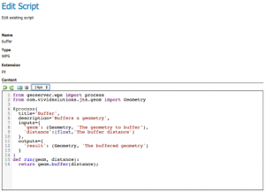
**Scripting community module: **a great new editor for editing scripts directly from the web application
-
New raster formats: NetCDF and GRIB support, for anyone dealing with multidimensional data. NetCDF is also supported as a WCS output format, and it allows to extract data hypercubes out of your WCS server. Finally, it is also possible to build multidimensional mosaics of NetCDF and GRIB files, and add to the using the harvest REST API.
-
Language and Internationalisation: Turkish support has been added and French, Korean, Polish, Romanian are all caught up with the latest developments. Spot a translation mistake? Help translate here: GeoServer Latest localizations
About GeoServer 2.6
Articles and resources for GeoServer 2.6 series:
-
Raster Views in GeoServer via the CoverageView concept (GeoSolutions)
-
Advanced Raster Projection in GeoServer (GeoSolutions)
-
Supporting Wind Barbs In GeoServer and GeoTools (GeoSolutions)
-
GeoServer now supports Vector Footprints for ImageMosaic (GeoSolutions)
GeoServer at FOSS4G
Thanks to PDX-OSGeo local chapter and the organising committee of FOSS4G for a great event. We had a great time meeting everyone, enjoyed an excellent and diverse program, and productive weekend code sprint.
Marcus Sen and Jody Garnett have kindly gathered up links to GeoServer content.
Group Talks:
-
GeoServer Feature Frenzy (slides)— Jody Garnett, Boundless, Andrea Aime, GeoSolutions (Best of GeoServer as described by our email list)
-
State of GeoServer and GeoTools 2014 (slides)— Jody Garnett, Boundless, Andrea Aime, GeoSolutions, Justin Deolivera, Boundless _(Skip to the end for a peek at the 2.7.0 roadmap/wish list) _
GeoServer Talks:
-
Advanced Security With GeoServer (slides)— Mauro Bartolomeoli, GeoSolutions Sas
-
Raster Data In GeoServer And GeoTools: Achievements, Issues And Future Developments (slides)— Andrea Aime
-
Mapping in GeoServer with SLD and CSS (slides)— Andrea Aime
-
GeoScript - A Geospatial Swiss Army Knife — Justin Deoliveira
Comparative Evaluations:
-
Evaluation of Web Processing Service Frameworks, Ebrahim Poorazizi, University of Calgary, Andrew J.S. Hunter, University of Calgary
-
WPS Benchmarking Session — Gérald Fenoy, GeoLabs SARL (Big thanks to Gérald as cross project presentations are a lot of work. Kudos to Ian Turton for setting up GeoServer WPS for benchmark)
Vertical Integration:
-
Big size meteorological data processing and mobile displaying system using PostgresSQL and GeoServer — Jaehyun Kwun, Gaia3D
-
Adopting OGC Standards in a Flood Alert System — Ivan Martinez, FCTH / SAISP
-
Integrating FOSS4G into an enterprise system for Disaster Management — David Askov
-
Scaling for NYC while Tracking Plows — Colin Reilly, NYC DoITT
-
Supporting Open Data with Open Source — Micah Wengren, NOAA, Jeff de la Beaujardiere, NOAA
-
GeoMesa: Distributed Spatiotemporal Analytics — Anthony Fox, Commonwealth Computer Research, Inc (A great example of hooking GeoServer up to big data - see abstract wednesday, Session 3, Track 6)
-
Open Source Social Media Aggregation and Geolocating for Emergency Management — Dan King, Viewpoint Computer Services
-
Web and mobile enterprise applications — Peter Batty, Ubisense
-
Case Study of Brazilian Institute of Environment and Renewable Natural Resources with FOSS GIS Marcelo Soares Souza, Hex - Tecnologias Geospaciais Inovadoras (Sorry no video link!)
-
MapStory: The next plateau — Ian Schneider
-
GeoTools, GeoServer, GeoGit: A Case Study of Use in Utility Field Work — Peter Hansen (Shucks - looks like Peter found an experiment on GitHub and did not talk to developers)
Misc / GeoTools:
-
Using FOSS Tools, UAVs and Linear Referencing to Better Manage Federal Levee Data — Wilhelm Breitkreutz, U.S. Army Corps
-
Open Web Mapping: An educational resource for creating online maps using free and open source software (About a course in using FOSS4G tools including GeoServer)
-
PyWPS - 4 project report — Jachym Cepicky (Planning to support GeoServer for complex data management and serving in the future)
-
Tileserver on a diet using node.js — Igor Tihonov, Hemnet (Rejected use of GeoServer)
Java Code Sprint
Day 1 Quality Assurance
Thanks to the foss4g and WhereCampPDX for
Automated Testing with CITE Team Engine
Andrea and Justin have lead the charge updating the GeoServer CITE tests (see Cite Sprint).
The goals are initially modest: enable developers (other than Justin) to setup and run CITE tests.
Justin is working on updating our “easy to use” CITE test harness build, while the others are hitting the latest version of the CITE tests and checking both ends, tests and GeoServer, for errors (and finding issues on both sides): Andrea Aime is working WCS tests, Mauro Bartolomeoli on the WFS ones, Jared Erickson and Brad Hards on the WMS ones.
GeoServer Manual Testing with 2.6 Nightly
Our plea to test 2.6-RC1 was not incredibly successful, so we are in for a bit of manual testing:
-
2.6-beta released <– contains our “help please” test request
-
2.6-x Nightly Build <– update: fixed download link for nightly releases
Thanks: Cristiane Andrioli, Flavio Conde, Ivan Martinez
Random fixes:
-
Update link for nightly release (Jody)
-
Nightly build is running again (Justin)
-
Documentation for weather symbols, custom WKT symbols, bulk custom WKT geometry
-
Testing of marlin, install instructions, package as geoserver extensions (Chris Marx, Ian Turton)
-
Testing Oracle+Curved test (Ian Turton)
GeoServer Day 2
If you would like to join us tomorrow:
- Sunday, September 14th: Boundless is arranging facilities at nedspace from 10am-4pm.
Tutorials
- How to style layers using GeoServer and QGIS
- How to Publish a GeoTIFF file in GeoServer
- A Comprehensive Guide to Publishing a Shapefile in GeoServer
- GeoServer About & Status - A Practical Guide
- GeoServer installation methods on Windows
- Introducing GeoSpatial Techno with a Video Tutorial
- GeoServer Presentations on FOSS4G 2019