GeoServer 2.26.0 release is now available
with downloads
(bin,
war, windows), along with
docs and
extensions.
This is a stable release of GeoServer recommended for production use.
GeoServer 2.26.0 is made in conjunction with GeoTools 32.0, GeoWebCache 1.26.0, ImageIO-EXT 1.4.13, and JAI-EXT 1.1.27.
Thanks to Peter Smythe (AfriGIS) and Jody Garnett (GeoCat) for making this release and everyone who has helped out during this release cycle.
Special thanks Andrea for helping with release announcement, and Torben for troubleshooting the build server and docker environment for this release.

Nightly build testing
This release cycle we asked our new user forum to test a nightly build, as we did not have capacity to make a release candidate.
Thanks to Daniel Calliess for responding during our public testing cycle. Daniel noted that he had to add /geoserver/webresources to his proxy for the OpenLayers preview to function. This change is due to an ongoing effort to move all CSS and JS to external resources allowing Content Security Policy headers to be introduced.
Security Considerations
This release addresses security vulnerabilities and is a recommended upgrade for production systems.
- CVE-2024-34711 Improper ENTITY_RESOLUTION_ALLOWLIST URI validation in XML Processing (SSRF) (High 7.3)
- CVE-2024-35230: Welcome and About GeoServer pages communicate version and revision information (Moderate 5.3)
See project security policy for more information on how security vulnerabilities are managed.
- GEOS-11400 About Page Layout and display of build information
Java 17 Support
The binary distribution and the Windows installer now work with Java 17.
When using the war distribution with Tomcat and Java 17 double check the Server status page.
If the Java Rendering Engine is listed as “Unknown”, double check the Running in Java 17 production considerations.

Thanks to Andrea Aime and everyone who worked on testing this in different environments.
- GEOS-11467 Update Marlin, make the bin package compatible with Java 17
Docker Updates
The base image tomcat:9.0.95-jdk17-temurin-jammy is now used - providing the latest Tomcat 9 and Java 17. The docker crew changed from using ubuntu:22.04 with our own Tomcat install script earlier in the year.
To try out GeoServer 2.26.0 with docker:
docker pull docker.osgeo.org/geoserver:2.26.0
docker run -it -p8080:8080 docker.osgeo.org/geoserver:2.26.0
Thanks to Nils Bühner (terrestris) and everyone who has contributed to the Docker build.
Search improvement
A small but fun change for the layer preview - it is now easier to find just the layer you are looking for using quotes to isolate an individual word.

Thanks to Alessandro Ricchiuti for this work.
- GEOS-11351 Exact term search in the pages’ filters
Extensive MapML Improvements
Thanks to Natural Resources Canada for sponsoring an extensive set improvements for the MapML extension.

This update was carried out by a group of GeoSolutions devs, Andrea Aime, Daniele Romagnoli and Joseph Miller.
- GEOS-11322 MapML WMS Vector Representation include query filter
- GEOS-11324 MapML WMS Vector Representation Style Classes
- GEOS-11337 Support feature tiles in MapML
- GEOS-11349 MapML Use WMS Resource Consumption Limit to specify max image size
- GEOS-11461 Enable MapML Viewer output for WFS getFeature.
- GEOS-11486 Adding custom dimensions to MapML
- GEOS-11528 Update MapML viewer to latest release 0.14.0
- GEOS-11471 Remove Sharding configuration support from MapML
Demo Requests page rewritten
The Demo Request page has been rewritten to use JavaScript to issue POST examples. This provides a much better user experience:
- Show Result lists the response headers to be viewed along side the returned result (with an option for XML pretty printing).
- Show Result in a New Page is available to allow your browser to display the result.
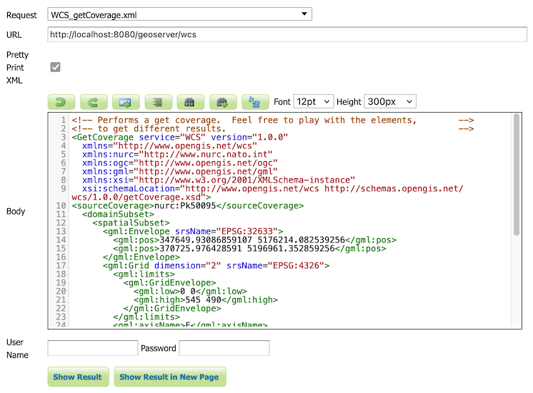
The WCS Request Builder and WPS Request Builder demos now have the option to show their results in Demo Requests page. Combined these changes replace the previous practice of using an iframe popup, and have allowed the TestWfsPost servlet to be removed.
For more information please see the Demo requests in the User Guide.
Thanks to David Blasby (GeoCat) for these improvements, made on behalf of the GeoCat Live project.
- GEOS-11390 Replace TestWfsPost with Javascript Demo Page
JTS 1.20.0 Update
We are overjoyed to update to the latest JTS 1.20.0 release which includes a new implementation of spatial relationships.
Use -Djts.relate=ng to try out the new implementation (replacing RelateOp with theReleateNG next generation implementation). Let us know how it goes, a future update will make this setting the default and expand the approach to “prepaired geometry” bulk operations used for WFS Queries.
Thanks to Martin Davis (CrunchyDB) for the JTS improvements, and Jody Garnett (GeoCat) for the release and GeoServer update.
Raster Attribute Table Extension
A new extension is available that takes advantage of the GDAL Raster Attribute Table (RAT). This data structure provides a way to associate attribute information for individual pixel values within the raster. This provides a table that links each cell value in the raster to one or more attributes on the fly.
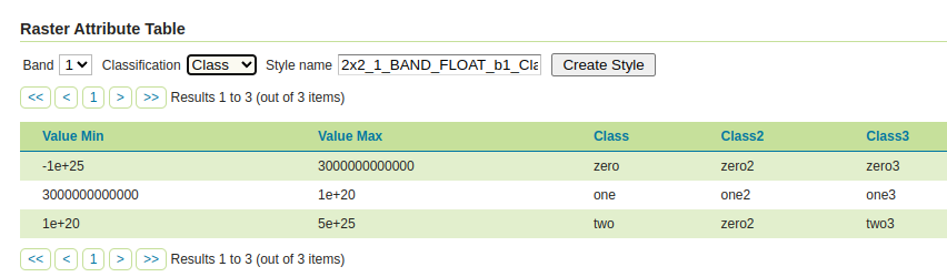
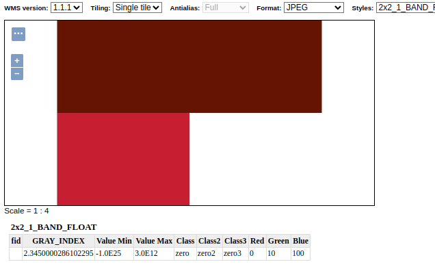
Thanks to Andrea Aime (GeoSolutions) for the development and NOAA for sponsoring this new capability. Please see the user guide Raster Attribute Table support for more information.
- GEOS-11376 Graduate Raster Attribute Table to extension
GeoCSS improvements
GeoCSS can now perform scale dependent rendering by the zoom level, assuming web mercator by default, but allowing the configuration of a different gridset as well. It’s also possible to create multi-layer styles and use them as style groups.
@mode 'Flat';
@TileMatrixSet 'WorldCRS84Quad'

tiger:poly_landmarks {

  /* @title parks and green spaces */
  [CFCC in ('D82', 'D32', 'D84', 'D85')] {
    fill: #B4DFB4;
    stroke: #88B588;
  };
  …
}

tiger:tiger_roads [@z > 12] {
  stroke: #666666, #FFFFFF;
  stroke-width: 6, 4;
  z-index: 1, 2;
  …
}

…
Thanks to Andrea Aime (GeoSolutions) for this work, performed in preparation for the FOSS4G-NA 2024 vector tiles workshop.
Geostationary satellite AUTO code
AUTO:97004 has been introduced as a new vendor extension to WMS AUTO codes. It implements the geostastionary satellite project and allows to change the central meridian as part of the GetMap request.

Thanks to Andrea Aime (GeoSolutions) for this work, and Eumetsat for sponsoring it.
labelPoint function improved
The labelPoint function has been improved with more precise calculation of the polygon label points, and not requiring to specify a tolerance any longer. This helps get better maps, especially with tiling enabled (fixed labelling point no matter which tile is requested):
  <sld:TextSymbolizer>
    <sld:Geometry>
      <ogc:Function name="labelPoint">
        <ogc:PropertyName>the_geom</ogc:PropertyName>
      </ogc:Function>
    </sld:Geometry>
  </sld:TextSymbolizer>


Thanks to Andrea Aime (GeoSolutions) for this work, performed in preparation for the FOSS4G-NA 2024 vector tiles workshop.
Improved vector tiles generation
A few new vendor options have been added in GeoServer, that control how vector tiles are built, with the objective of producing smaller, faster, more useful vector tiles.
vt-attributes: comma separated list of attributes included in the vector tilevt-labels: when true, generates a sidecar -label layer for polygons, with the label point of the polygon (vector tile clients generally cannot produce a good label placement otherewise)vt-label-attributes:: attributes included in the label point layervt-coalesce: if true, takes all features in the tile sharing the same attribute values, and coalesces their geometries into a single multi-geometry.
Here is an example style using the above vendor options, in GeoCSS:
@mode "Flat";

tiger:poly_landmarks {
  fill: gray;
  vt-attributes: 'CFCC,LANAME';
  vt-labels: true;
}

tiger:tiger_roads [@z > 11] {
  stroke: black;
  vt-attributes: 'NAME';
  vt-coalesce: true;
}

tiger:poi [@z > 12] {
  mark: symbol(square);
}
The GWC layer preview has also been improved to show the vector tile feature attributes on hover:

Thanks to Andrea Aime (GeoSolutions) for this work, performed in preparation for the FOSS4G-NA 2024 vector tiles workshop.
GeoPackage QGIS Compatibility Improvements
A number of issues affecting interoperability with QGIS have been addressed:
GeoPackage extension output could contain field types that are not supported by GDAL.
It turns out the GeoPackage export was picking up some of the file type information intended for PostGIS
resulting output that could not be read by other programs such as QGIS.
We were also able to fix up the TIMESTAMP information representation as DATETIME, making the file format timezone agnostic as intended.

Thanks to David Blasby (GeoCat) for these fixes made on behalf of Zeeland and South Holland.
- GEOS-11416 GeoPackage output contains invalid field types when exporting content from PostGIS
New image mosaic merge behaviors, MIN and MAX
These two new image mosaic merge modes activate when multiple images overlap with each other, choosing respectively the minimum and maximum value amongst the super-imposed pixels.

Thanks to Andrea Aime for the work, and the US National Research Laboratory for sponsoring it.
Release notes
New Feature:
- GEOS-11322 MapML WMS Vector Representation include query filter
- GEOS-11324 MapML WMS Vector Representation Style Classes
- GEOS-11352 REST service for URL checks
- GEOS-11376 Graduate Raster Attribute Table to extension
- GEOS-11390 Replace TestWfsPost with Javascript Demo Page
- GEOS-11414 Adding css-uniqueRoleName
Improvement:
- GEOS-11271 Upgrade spring-security to 5.8
- GEOS-11325 Add properties to set additional security headers
- GEOS-11337 Support feature tiles in MapML
- GEOS-11338 CapabilityUtil SearchMinMaxScaleDenominator should include support for multiple NamedLayers
- GEOS-11349 MapML Use WMS Resource Consumption Limit to specify max image size
- GEOS-11351 Exact term search in the pages’ filters
-
| GEOS-11369 Additional authentication options for cascaded WMS |
WMTS data stores |
- GEOS-11370 Refactor inline JavaScript in the TestWfsPost Page
- GEOS-11371 Refactor inline JavaScript in the GetMap OpenLayers format
- GEOS-11379 Refactor inline JavaScript in the OGC API modules
- GEOS-11400 About Page Layout and display of build information
- GEOS-11401 Introduce environmental variables for Module Status page
- GEOS-11427 metadata: “fix all” to support changing config repeatable field
- GEOS-11443 REST API does not take effect immediately due to 10 minute authentication cache
- GEOS-11461 Enable MapML Viewer output for WFS getFeature.
- GEOS-11467 Update Marlin, make the bin package compatible with Java 17
- GEOS-11477 Add a max and a min merge mode for image mosaics
- GEOS-11486 Adding custom dimensions to MapML
- GEOS-11488 Double-Click-to-Copy featurecaption variable reference
- GEOS-11495 Support multi-layer output in CSS
- GEOS-11502 Permit resize on user/group/role palette textbox to allow for extra long role names
- GEOS-11503 Update mongo schemaless DWITHIN to support non-point geometry
- GEOS-11515 Add support for zoom level rule filtering in CSS
- GEOS-11526 GeoFence: slow GeoServer response when there are many roles and layergroups
- GEOS-11527 Add new vector tiles generation options in style body: vt-attributes, vt-coalesce, vt-labels, vt-label-attributes
- GEOS-11528 Update MapML viewer to latest release 0.14.0
- GEOS-11531 When coalescing linestrings in vector tiles output, fuse them to create a single long line
Bug:
- GEOS-7183 Demo request/wcs/wps pages incompatible with HTTPS/PKI
- GEOS-11202 CAS extension doesn’t use global “proxy base URL” setting for service ticket
- GEOS-11266 csw-iso: missing fields in summary response
- GEOS-11314 Error in IconService when style has multiple FeatureTypeStyle
- GEOS-11385 Demo Requests functionality does not honour ENV variable PROXY_BASE_URL
- GEOS-11416 GeoPackage output contains invalid field types when exporting content from PostGIS
- GEOS-11422 MapML License Metadata Stored With Incorrect Keys
- GEOS-11430 CiteComplianceHack not correctly parsing the context
- GEOS-11446 [INSPIRE] Incorrect behavior for unsupported languages
- GEOS-11462 500 error thrown when double adding a user to a group via REST with JDBC user/group services
- GEOS-11484 DirectRasterRenderer is not respecting advancedProjectionHandling and continuosMapWrapping format_options
- GEOS-11530 Adding or removing a grid subset in the layer caching tab, causes the grid dropdown to get duplicated
Task:
- GEOS-11341 Upgrade NetCDF to 5.3.3
- GEOS-11360 Upgrade Apache POI from 4.1.1 to 5.2.5
- GEOS-11362 Upgrade Spring libs from 5.3.32 to 5.3.33
- GEOS-11374 Upgrade Spring version from 5.3.33 to 5.3.34
- GEOS-11375 GSIP 224 - Individual contributor clarification
- GEOS-11393 Upgrade commons-io from 2.12.0 to 2.16.1
- GEOS-11395 Upgrade guava from 32.0.0 to 33.2.0
- GEOS-11397 App-Schema Includes fix Integration Tests
- GEOS-11402 Upgrade PostgreSQL driver from 42.7.2 to 42.7.3
- GEOS-11403 Upgrade commons-text from 1.10.0 to 1.12.0
- GEOS-11404 Upgrade commons-codec from 1.15 to 1.17.0
- GEOS-11407 Upgrade jackson from 2.15.2 to 2.17.1
- GEOS-11464 Update Jackson 2 libs from 2.17.1 to 2.17.2
- GEOS-11470 Upgrade the version of Mongo driver for schemaless plugin from 4.0.6 to 4.11.2
- GEOS-11471 Remove Sharding configuration support from MapML
- GEOS-11472 Upgrade freemarker from 2.3.31 to 2.3.33
- GEOS-11473 Upgrade guava from 33.2.0 to 33.2.1
- GEOS-11475 Upgrade commons-codec from 1.17.0 to 1.17.1
- GEOS-11478 Upgrade commons-lang3 from 3.14.0 to 3.15.0
- GEOS-11479 Upgrade junit from 4.13.1 to 4.13.2
- GEOS-11480 Update map fish-print-lib 2.3.1
- GEOS-11506 Upgrade Spring version from 5.3.37 to 5.3.39 and Spring security from 5.8.13 to 5.8.14
- GEOS-11508 Update OSHI from 6.4.10 to 6.6.3
- GEOS-11512 Upgrade jasypt from 1.9.2 to 1.9.3
- GEOS-11532 Update to JTS 1.20.0
- GEOS-11533 Update org.apache.commons.vfs2 to 2.9.0
- GEOS-11544 Upgrade to ImageIO-EXT 1.4.13
- GEOS-11545 Update to JAI-EXT 1.1.27
For the complete list see 2.26.0 release notes.
Community modules are shared as source code to encourage collaboration. If a topic being explored is of interest to you, please contact the module developer to offer assistance.
Community module development:
- GEOS-10690 Task manager plugin is missing dependencies
- GEOS-10824 gs-flatgeobuf extension can clash with “directory of shapefiles” datastores
- GEOS-11331 OAuth2 can throw a “ java.lang.RuntimeException: Never should reach this point”
- GEOS-11358 Feature-Autopopulate Update operation does not apply the Update Element filter
- GEOS-11381 Error in OIDC plugin in combination with RoleService
- GEOS-11412 Remove reference to JDOM from JMS Cluster (as JDOM is no longer in use)
- GEOS-11466 move reusable elements of the graticule plugin to GeoTools
- GEOS-11469 Datadir catalog loader does not decrypt HTTPStoreInfo passwords
- GEOS-11518 DGGS JDBC store SQL encoder should not force the timezone to CET
- GEOS-11519 Make DGGS rHealPix tests run again
- GEOS-11521 Expose a JNDI variant of the DGGS Clickhouse datastore
- GEOS-11541 STAC search endpoint sortby query not working with POST
OGC APIs feeling “at home”
OGC API modules now nicely slot into the home page in the corresponding functional section, e.g., since both provide raw vector data, both OGC API Features and WFS show up in the same area:

Thanks to David Blasby (GeoCat) for this work.
Data directory loader
The “Data Directory loader”, by Gabriel Roldan (Camptocamp), is a replacement data directory loader, reading the XML configuration files at startup. It has been optimized to achieve better parallelism and be more efficient over network file systems.
It can be found amongst the nightly builds, it’s a simple drop in replacement, just unzip the plugin in WEB-INF/lib and restart. Let us know how it works for you.
WFS HTML Freemarker output
The WFS HTML Freemaker output format is a community module generating HTML in response to GetFeature, using the GetFeatureInfo Freemarker templates.
Thanks to Alessio Fabiani (GeoSolutions) for starting this activity.
Graticule module
The graticules module is the combination of a data store and a rendering transformation allowing to generate graticules at multiple resolutions, and optionally placing the graticule labels at the map borders.

Thanks to Ian Turton for working on this activity. Ian needs a few more people to try this out before it can be included in our GeoServer roadmap.
Developer Updates
GeoServer team has identified quite the challenges for GeoServer 2024 Roadmap Plannings.
Wicket Progress
After initial testing of 2.26-M0 milestone release we held off including Wicket 9 until after the 2.26.0 release. Thanks to Peter Smythe and Jody Garnett for testing.
Thanks to Brad Hards who started this work in November 2023, and David Blasby who helped bring this up to a state it could be tested ahead of the 2.26.0 release.
Spring Security 5.8
Thanks to Andreas Watermeyer (ITS Digital Solutions) completed this important update.
This is the last stopping place before Spring Security 6, and the last chance to work with the OAuth2 community modules.
About GeoServer 2.26 Series
Additional information on GeoServer 2.26 series:
Release notes:
( 2.26.0
| 2.26-M0
)
]]>