GeoServer 2.6.0 Released
The GeoServer team is pleased to account the greatly anticipated 2.6.0 release. This release is now available for download with zip, war, dmg and exe bundles available (see the change log for details on last minute fixes).
Thanks to the user list for testing the 2.6-beta and 2.6-RC1, this collaboration and testing really helped smooth our migration to Java 7. The Code Sprint at FOSS4G was able to fill in gaps testing oracle curve support, the marlin extension on a range of platforms, and providing documentation introducing wind barbs and inline custom marks.
Thanks to Ian Turton, Jody Garnett and Kevin Smith for assisting in this release. This release is made in conjunction with GeoTools 12.0.
Java 7
Ensure you are using Oracle o OpenJDK Java 7.
Support for Java 7 is not only a new feature for GeoServer 2.6.0 - Java 7 is a requirement.
The installation instructions have been updated for windows, mac and linux users. Mac users will have an easy upgrade as GeoServer.app includes an appropriate Java 7 virtual machine.
New and Improved
New functionality:
-
**WFS Cascade: **WFS Cascade has been updated to use a brand new GeoTools wfs client implementation.
-
Curve support for GML and WMS: GeoServer curve support has been added for interaction with Oracle Spatial. To configure look for Linearization tolerance when configuring your layer. As outlined in the FOSS4G presentation we are seeking interested parties to implement or fund curve support for PostGIS and SQL Server.
-
Advanced Projection Handling: Considerable care has been taken in the handling of raster data across the dateline and in polar projections.
-
**Coverage Views: **recombine bands from different sources into a multi-band coverage (use “configure new coverage view” when creating a new layer).

-
Vector footprints support in image mosaics: you can now cut out of your images the “bad” parts using vector footprints, setup as sidecar wkb/wkt files, or as a global footprints shapefile
-
**Pluggable Styles: **this change allows greater integration with the CSS Extension (and opens the door for even more style languages in the future)
-
Wind Barbs and WKT Graphics: for greater creative control.
-
**Printing: **new implementation from our friends at MapFish (based on MapFish 2.x).
-
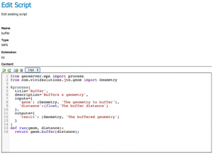
**Scripting community module: **a great new editor for editing scripts directly from the web application
-
New raster formats: NetCDF and GRIB support, for anyone dealing with multidimensional data. NetCDF is also supported as a WCS output format, and it allows to extract data hypercubes out of your WCS server. Finally, it is also possible to build multidimensional mosaics of NetCDF and GRIB files, and add to the using the harvest REST API.
-
Language and Internationalisation: Turkish support has been added and French, Korean, Polish, Romanian are all caught up with the latest developments. Spot a translation mistake? Help translate here: GeoServer Latest localizations
About GeoServer 2.6
Articles and resources for GeoServer 2.6 series:
-
Raster Views in GeoServer via the CoverageView concept (GeoSolutions)
-
Advanced Raster Projection in GeoServer (GeoSolutions)
-
Supporting Wind Barbs In GeoServer and GeoTools (GeoSolutions)
-
GeoServer now supports Vector Footprints for ImageMosaic (GeoSolutions)