GeoServer 2.20.0 Released
We are happy to announce GeoServer 2.20.0 is available for download (bin, war, windows) along with docs and extensions.
This the first stable release of the 2.20.x series and recommended for production systems. This release is made in made in conjunction with GeoTools 26.0 and GeoWebCache 1.20.0.
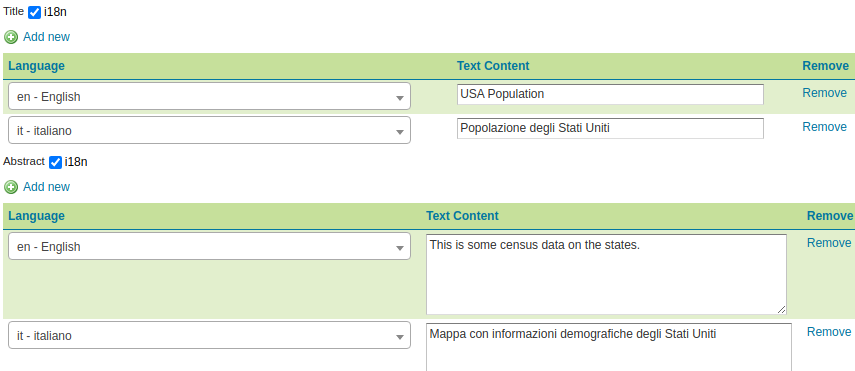
Internationalization
The leading feature for this release is the internationalization of Title, Abstract and Contact details for:
- WMS 1.1 and 1.3
- WFS 2.0
- WCS 2.0
See documentation for internationalization support and GSIP-203 proposal for details.
New feature:
- GEOS-10123 Internationalization for title and abstract
- GEOS-10207 Allow creation of internationalized raster legends
- GEOS-10190 i18n support for Contact Information
- GEOS-10185 LayerGroup legend internationalization styles returns multiple values
- GEOS-10177 Allow Default Translation
- GEOS-10129 Add language function for multilingual support in sld
Improvements and fixes:
- GEOS-10205 Layer with i18n title might appear twice in the capabilities, while being contained in a named tree
- GEOS-10204 Default locale is not being used while producing internationalized outputs in Capabilities document
- GEOS-10160 Requested Language in GetCapabilities
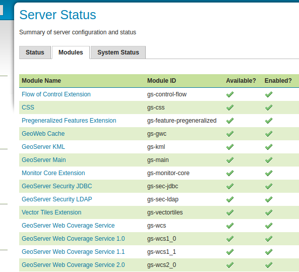
Modules Status Information for Extensions
Thanks to Ian for completing a [long outstanding request][https://osgeo-org.atlassian.net/browse/GEOS-10067] to provide listing everything you have installed:
- The Server Status page now provides a complete list of the loaded modules and extensions
- This extension list can also be checked via REST API (allowing scripts to check if the functionality they require has been installed)
New Feature:
- GEOS-10067 Implement module status in extensions (GISP-143)
Improvements and fixes:
- GEOS-9967 Add Module Status implementation for CSW Extension
Updates and quality assurance
GeoServer continues to be build with the latest open source technologies:
- GeoTools 26-RC
- GeoWebCache 1.20-RC
- JAI-EXT 1.1.20
- ImageIO-EXT 1.3.10
- JTS 1.18.2
- GeoFence 3.5.0
- Flatgeobuf to 3.10.1
The team continues to work with automated code checks, gradually improving the codebase and introducing checks to ensure issues are not re-introduced over time:
- Check system.out.println and printStackTrace statements are not accidentally committed, which can add to logs
- Cognitive complexity checks, start cleaning up methods that are too complex
- Use StandardCharsets when possible, rather than String
- Avoid unnecessary object wrapper creation
- Use short arrays initializers
- Work towards consistent style with checks to avoid C style array declarations, add missing @Override annotations, and check java generics are used
This dedication helps provide confidence in the technology we publish.
WMS
Fixes and improvements:
- GEOS-4939 Coordinate system ISSUE - S-JTSK Krovak East North (
EPSG: 5514) - cannot be set up - GEOS-10032 Group Layer in Catalog Mode Hide not in capabilities when unauthenticated
- GEOS-10013 Mark invalid error while validating or saving a Style
- GEOS-9907 Enable usage of labelPoint function in GetFeatureInfo requests
- GEOS-9759 Set Response Cache Headers in LayerGroups
The following functionality has been removed:
-
GEOS-10001 Remove animator and animated GIF support from WMS
Use of WPS Animation process is provided as an alternative
WFS
Fixes and improvements:
- GEOS-10222 WFS CSV OutputFormat delimiter
WPS
Fixes and improvements:
- GEOS-9990 Add GUI and REST API to configure the wps-download module
- GEOS-10073 WPS animation download process should report about eventual time mis-matches
WMTS
Improvements and fixes:
- GEOS-10008 Have GeoServerTileLayer implementing TileJSONProvider
- GEOS-9971 GeoWebCache S3 plugin require AWS creds
INSPIRE Extension
New feature:
- GEOS-10124 Add Language support to INSPIRE extension
Improvements and fixes:
- GEOS-10211 Unable to pass INSPIRE validation: Version is mandatory (WMS)
- GEOS-10192 Inspire extension consistent outputResponse element
- GEOS-10141 Inspire extension better error message on language not found
- GEOS-10163 Incorrect INSPIRE namespace URI
And more!
Fixes and Improvements:
- GEOS-10092 Fix the page description of remote WMS/WMTS connection
- GEOS-10189 I18n improvement using the UTF-8 charset for Chinese translations
- GEOS-10033 Geoserver startup and shutdown shell scripts don’t handle path with spaces
- GEOS-9381 Conversion from boolean true/false in geoserver to SQL Server bit 0/1, is broken
- GEOS-9970 MapML GetFeature bug fix for CRS authority
- GEOS-10201 Geoserver fails to start on Windows 11 beta
- GEOS-10264 Address startup warning File option not set for appender [geoserverlogfile]
- GEOS-9950 MapPreviewPage logs unable to find property: format.wfs.text/csv continuously
- GEOS-10265 WFS-T Bulk Transaction optimization
About GeoServer 2.20
Additional information on GeoServer 2.20 series: