GeoServer 2.21.0 Release
GeoServer 2.21.0 release is now available with downloads (bin, war, windows), along with docs and extensions.
This is a first release of the new stable branch of GeoServer and is made in conjunction with GeoTools 27.0 and GeoWebCache 1.21.0.
- GeoServer now supports Java 17! This is likely to be the last release that supports Java 8 and we encourage users to start to make the transition to Java 11 during the lifetime of this branch.
- Thanks to everyone who help tested the release candidate on and off list: Daniel Calliess, Georg Weickelt, Stefan Overkamp, Nicolas Matzick, Sander Schaminee, Jose Garcia, Rosa Briones, Jody Garnett, Andrea Aime, Ian Turton.
Thanks to Ian Turton, Astun Technology, for making this release.
Feature Type Customization
We are pleased to share a long-requested feature - the ability to rename attributes and change attribute order when publishing a FeatureType.
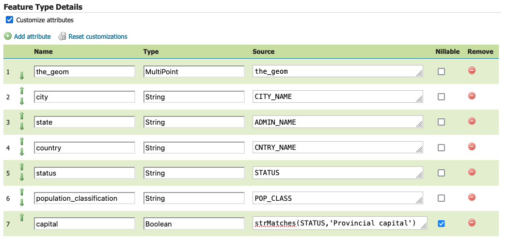
It is also possible to change attribute type, and with the use of ECQL expressions generate new attributes on the fly.
The above example works around the limitations of shapefile to use longer names, and creates a new attribute capital on the fly from an expression, as shown in the following GetFeatureInfo output.

This is a great new addition to GeoServer, please see Feture Type Details in the user guide for details.
- GEOS-10356 Allow feature type customization
Thanks to Andrea Aime (GeoSolutions) for proposal GSIP-207 and implementation, and Canton of Solothurn for funding the work.
Translations and Language Chooser
A big thanks to Alexandre Gacon and everyone who helped improve GeoServer internationalization for during this release cycle.
To support this activity Andrea Aime has contributed a language chooser to the top of the screen (near the login button).
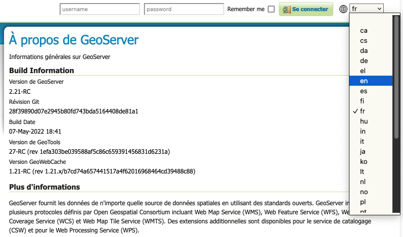
For more information see Choosing the UI language (User Guide).
- GEOS-1158 Specify Geoserver UI Language in Configuration
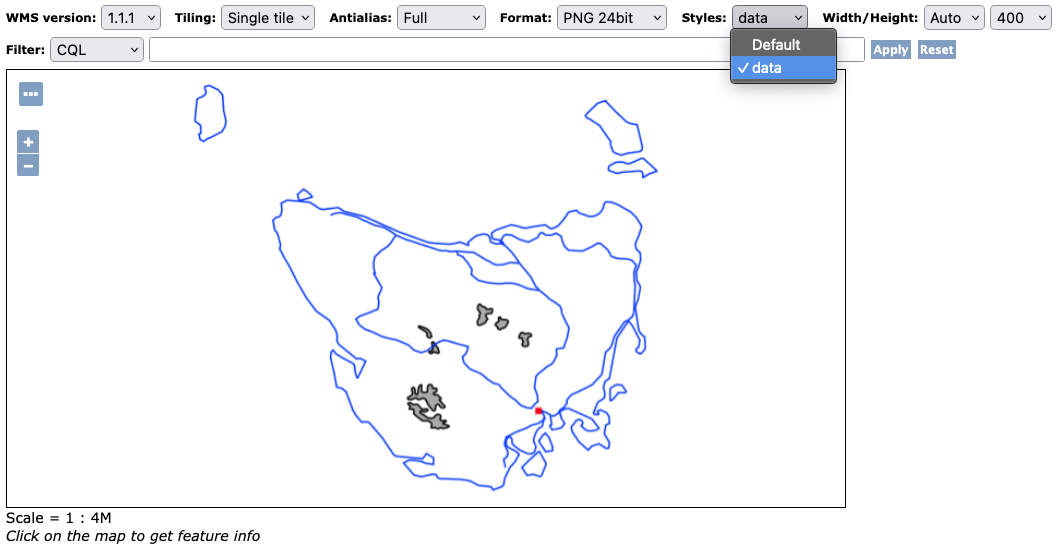
Add Styles support to LayerGroup
Layer groups can now be configured with additional styles, with each style listing a series of layers along with the style used to render each layer.
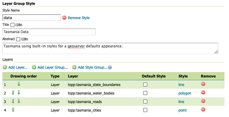
This allows a SINGLE or OPAQUE layer group to list alternate styles in addition to the default one. Each alternate style is defined by a named configuration of layers and styles providing a unique visual representation.
In the above example the layer group Tasmania is setup with an alternate “data” presentation, presenting the content with the geoserver default styles point, line and polygon.
For more information see Layer Group Styles (User Guide).
- GEOS-10252 Add Styles support to LayerGroup
- GEOS-10274 Geofence follow up LayerGroup Style addition
Thanks to Marco Volpini (GeoSolutions) for GSIP-205 proposal and implementation, and the Swedish Agency for Marine and Water Management for sponsoring this new functionality.
GeoPackage WMS and WFS Output
The result of proposal GSIP-206 is the creation of the gs-geopkg-output extension packaging up the WFS and WMS output formats from the geopackage community module.
curl "http://localhost:8080/geoserver/wfs?service=wfs&version=2.0.0&request=GetFeature&typeNames=topp:states&outputFormat=geopkg" -o wfs.gpkg
For more information see Using the GeoPackage Output Extension in the user guide.
- GEOS-10351 [GSIP 206] Promote GeoPackage WFS and WMS output formats to an extension
- GEOS-8793 WFS 1.1.0/2.0.0 GeoPackage output wrong Coordinate Order
Thanks to David Blasby and Jody Garnett (GeoCat) for packaging up this work as an extension. This work was supported in part by Rijkswaterstaat.
Mark Factory Precedence
When rendering maps with lots of individual graphics, looking up the correct implementation (known as a MarkFactory) can be time consuming.
WMS Settings have new capability to filter out any mark factories not being used, and provide an order to prioritise the ones being used.
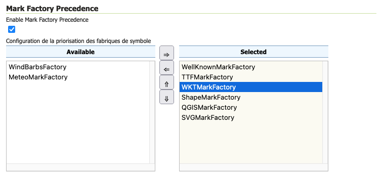
For more information see WMS Web Administration (user guide).
- GEOS-10230 MarkFactory WMS rendering performance optimization
Thanks to Fernando Mino (GeoSolutions Group) for troubleshooting this performance issue, and proposal GSIP-204 as an optimization. Thanks to EMSA for sponsoring the improvement.
Log4J 2 Upgrade
The assessment of Log4Shell vulnerability highlighted that although GeoSever was not affected, our use of the older Log4j 1.2 was a notable risk. This discussion resulted a small fundraising effort and proposal to upgrade to Log4j 2.
The result is a small change to the user interface, listing logging profiles by name (previously the file extension was also listed).
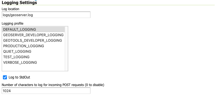
Internally this release changes from Log4j 1.2 logging profiles (using properties extension) to Log4j 2 logging profiles (using xml extension):
-
The built-in logging profiles (
DEFAULT_LOGGING,PRODUCTION_LOGGING, …) are replaced with new Log4j 2xmlfiles. -
Previous custom logging profiles will continue to be available (Log4J 2 has the ability to read the older Log4J 1.2 properties files).
-
If you made any customizations to the built-in profiles, you can recover your changes from backup
bakfile. You can use this backup as a reference when creating a newxmllogging profile, or restore this under a different name which does not conflict with the built-in logging profiles.A customization to
PRODUCTION_LOGGING.propertieswill be backed up toPRODUCTION_LOGGING.properties.bak. This can be restored by renamingPRODUCTION_LOGGING.properties.baktoCUSTOM_LOGGING.properties.
In addition to the INFO status messages, you will notice a new CONFIG logging level used during application startup:
CONFIG [org.geoserver] - GeoServer configuration lock is enabled
CONFIG [org.geoserver] - Loading catalog...
...
For more information, and examples of writing a Log4J 2 profile, see Logging Settings and Advanced log configuration in the User Guide.
- GEOS-10426 GSIP 167: Upgrade Log4j
Thanks to Jody Garnett (GeoCat) for completing this work, and to the following sponsors for supporting this activity.
Logging REST API
For more information please see Logging settings (User Guide) and GeoServer Logging (REST API).
- GEOS-10368 Logging Controller Addition allows configuration of logging via REST API.
Thanks to Yalın Eren Deliorman (GeoSolutions) for this contribution, and Eumetsat for sponsoring the work.
New WPS settings and KML input/output support
A number of improvements have been made to the WPS service:
-
GEOS-10443 Graduate kml-ppio community module to wps extension. Thanks to GeoSolutions for taking the maintainership of the module, and Masego Inc. for sponsoring the graduation work.
KML can now be used with WPS service for both input and output parameters.
-
GEOS-10391 Add external output directory setting to limit where processes can write
See WPS setting for external output directory in User Guide.
-
GEOS-10431 Add WPS setting to disable remote complex inputs.
See WPS Security and input limits in the User Guide.
Thanks to the GeoNode project for these WPS improvements.
GDAL 3.x Compatibility
The gdal-output extension is tested against GDAL 3.x series.
Please pay careful attention to the installation instructions, while the extensions includes gdal-3.2.0.jar you should double check the native binaries (included in your Linux distribution or installed by hand) and download an appropriate replacement jar online.
For more information see Installing GDAL native libraries in the User Guide.
- GEOS-10402 Upgrade imageio-ext to 1.4.0 (tested with gdal 3.2)
Thanks to Andrea Aime (GeoSolutions) for making the ImageIO-EXT release, and Jody Garnett (GeoCat) for GDAL 3.x upgrade and testing. This work was supported in part by Rijkswaterstaat.
Improvements and Fixes
New features:
- GEOS-10228 Add wrap_limit property to wrap the category text values of a legend
Improvements:
- GEOS-10146 App-schema: support for multiple geometries with different CRS
- GEOS-10246 jdbcconfig: performance slow-down from unnecessary transactions
- GEOS-10251 Refactor MapML vocabulary to map- custom elements HTML namespace
- GEOS-10463 Support WCS default value for Deflate Compression
- GEOS-10320 Support GetFeatureInfo on raster layers with transformations turning the output into vector
- GEOS-10405 GetFeatureInfo: Support multiple featureCollections per query layer
Fixes:
- GEOS-10226 ResourcePool leaves empty files on failure
- GEOS-10318 CSV output format for complex features doesn’t resolve namespace URIs to prefixes on attributes names
- GEOS-10235 Prevent double-quote to be specified as CSV separator
- GEOS-10477 SLD - Validation error on Normalize-node
- GEOS-10448 GetTimeSeries does not limit number of dates when using a time range request (without period)
- GEOS-10429 Style validation error using the VendorOption “graphic-margin”
- GEOS-10318 CSV output format for complex features doesn’t resolve namespace URIs to prefixes on attributes names
- GEOS-10502 GML3 output is not pretty printed when pretty print is turned on in global settings.
Tasks:
- GEOS-10458 Update jai-ext to 1.1.22
- GEOS-10446 Upgrade to commons-codec 1.15 version
- GEOS-10363 Switch from itextpdf to openpdf for PDF map rendering
About GeoServer 2.21
Additional information on GeoServer 2.21 series: