GeoServer 2.25.1 Release
GeoServer 2.25.1 release is now available with downloads (bin, war, windows), along with docs and extensions.
This is a stable release of GeoServer recommended for production use. GeoServer 2.25.1 is made in conjunction with GeoTools 31.1, and GeoWebCache 1.25.1.
Thanks to Jody Garnett (GeoCat) for making this release.
Security Considerations
This release addresses security vulnerabilities and is considered an essential upgrade for production systems.
2024-06-30 Update: The following mitigation has been provided:
-
CVE-2024-36401 Remote Code Execution (RCE) vulnerability in evaluating property name expressions (Critical)
geoserver-2.25.1-patches.zip (replacing
gt-app-schema,gt-complexandgt-xsd-corejars) has been provided by Andrea (GeoSolutions) -
CVE-2024-34696 GeoServer About Status lists sensitive Environmental Variables (Moderate)
See project security policy for more information on how security vulnerabilities are managed.
Raster Attribute Table Extension
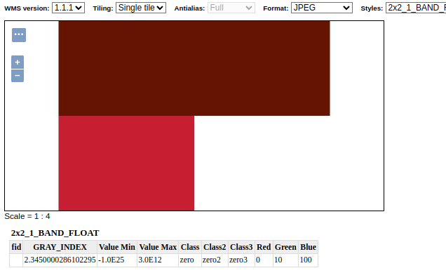
A new extension is available that takes advantage of the GDAL Raster Attribute Table (RAT). This data structure provides a way to associate attribute information for individual pixel values within the raster. This provides a table that links each cell value in the raster to one or more attributes on the fly.


Thanks to Andrea Aime (GeoSolutions) for the development and NOAA for sponsoring this new capability. Please see the user guide Raster Attribute Table support for more information.
- GEOS-11376 Graduate Raster Attribute Table to extension
Release notes
New Feature:
- GEOS-11267 CSW ISO extension multiple mappings should also have multiple queryable mappings
- GEOS-11376 Graduate Raster Attribute Table to extension
Improvement:
- GEOS-11306 Java 17 does not support GetFeature lazy JDBC count(*)
- GEOS-11311 Show a full stack trace in the JVM stack dump panel
- GEOS-11342 STAC should exclude items when the collection in path is wrong
- GEOS-11359 Update MapML viewer to release 0.13.2
-
GEOS-11369 Additional authentication options for cascaded WMS WMTS data stores - GEOS-11377 RAT module: allow to reload/recompute the RAT
- GEOS-11400 About Page Layout and display of build information
- GEOS-11401 Introduce environmental variables for Module Status page
Bug:
- GEOS-11202 CAS extension doesn’t use global “proxy base URL” setting for service ticket
- GEOS-11236 WFS 2.0.0/GetFeature - Shapefile - “We have had issues trying to flip axis”
- GEOS-11331 OAuth2 can throw a “ java.lang.RuntimeException: Never should reach this point”
- GEOS-11332 Renaming style with uppercase/downcase empty the sld file
- GEOS-11382 The interceptor “CiteComplianceHack” never gets invoked by the Dispatcher Servlet
- GEOS-11385 Demo Requests functionality does not honour ENV variable PROXY_BASE_URL
- GEOS-11392 ConcurrentModificationException while using proxy-base-ext
Task:
- GEOS-11360 Upgrade Apache POI from 4.1.1 to 5.2.5
- GEOS-11362 Upgrade Spring libs from 5.3.32 to 5.3.33
- GEOS-11374 Upgrade Spring version from 5.3.33 to 5.3.34
- GEOS-11375 GSIP 224 - Individual contributor clarification
- GEOS-11388 Update ImageIO-EXT to 1.4.10
- GEOS-11393 Upgrade commons-io from 2.12.0 to 2.16.1
- GEOS-11395 Upgrade guava from 32.0.0 to 33.2.0
- GEOS-11397 App-Schema Includes fix Integration Tests
- GEOS-11402 Upgrade PostgreSQL driver from 42.7.2 to 42.7.3
- GEOS-11403 Upgrade commons-text from 1.10.0 to 1.12.0
- GEOS-11404 Upgrade commons-codec from 1.15 to 1.17.0
For the complete list see 2.25.1 release notes.
Community Updates
Community module development:
- GEOS-11040 Could not get a ServiceInfo for service Features thus could not check if the service is enabled
- GEOS-11330 OAuth2 kid verification should be optional
- GEOS-11339 Introducing the Features Autopopulate Community Plugin
- GEOS-11340 WFS Freemarker HTML Outputformat
- GEOS-11345 STAC Conformance URIs need to be updated to v1.0.0
- GEOS-11348 JMS cluster does not allow to publish style via REST “2 step” approach
- GEOS-11358 Feature-Autopopulate Update operation does not apply the Update Element filter
- GEOS-11381 Error in OIDC plugin in combination with RoleService
- GEOS-11394 OGC APIs cannot handle time extent when the source data type is java.sql.Date
Community modules are shared as source code to encourage collaboration. If a topic being explored is of interest to you, please contact the module developer to offer assistance.
About GeoServer 2.25 Series
Additional information on GeoServer 2.25 series: