GeoServer 2.22-RC Release Candidate
GeoServer 2.22-RC release is now available with downloads (bin, war, windows), along with docs, extensions, and data directory. This release is also available as an Docker image.
This is a release candidate intended for public review and feedback.
Thanks to Jody Garnett (GeoCat) for making this release candidate.
Release candidate public testing and feedback
Testing and providing feedback on releases is part of the open-source social contract. The development team (and their employers and customers) are responsible for sharing this great technology with you.
The collaborative part of open-source happens now - we ask you to test this release candidate in your environment and with your data. Try out the new features, double check if the documentation makes sense, and most importantly let us know!
If you spot something that is incorrect or not working do not assume it is obvious and we will notice. We request and depend on your email and bug reports at this time. If you are working with commercial support your provider is expected to participate on your behalf.
Keeping GeoServer sustainable requires a long term community commitment. If you are unable to contribute time, sponsorship options are available via OSGeo.
Natural Earth GeoPackage and workspace
The sample data directory now includes a small geopackage generated from Natural Earth data. These layers are good examples with multiple styles, and include complete descriptions from the Natural Earth project.
Thanks to Jody Garnett (GeoCat), David Blasby (GeoCat), and the attendees of the FOSS4G GeoServer Beginner Workshop.
User Manual Getting Started updated
The user manual has been revised. Changes include:
-
Getting started has been updated and includes with new sections for GeoPackage, image, layer group and style.
-
Tutorials now provides an index of all tutorials across the user manual
Thanks to Jody Garnett (GeoCat) and the attendees of the FOSS4G GeoServer Beginner Workshop.
Welcome Page Updates
Layout
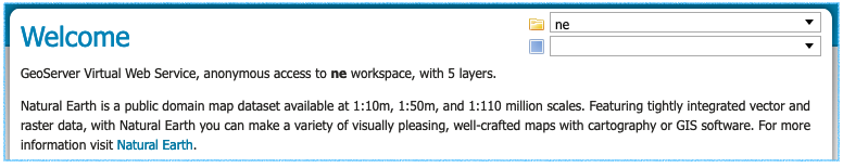
The welcome page description provides a summary of the workspaces and layers available to the current user.
The header includes a welcome message and a link to the organization providing the service.
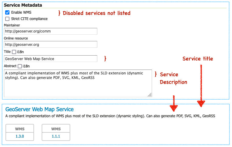
Each web service is listed using the service title as a heading, followed by the service abstract as a description. The protocols provided by the service are displayed as blocks linking to the web service URL. These are the URLs used to access the service in a desktop or web application.
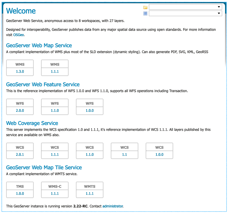
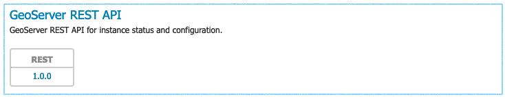
The services shown are based on the permissions of the current user. As an example when logged in as an Administrator the REST API service is shown with a link to the API endpoint.
For more information on the welcome page and an example of how to use service URLs in QGIS visit the user manual Welcome reference page.
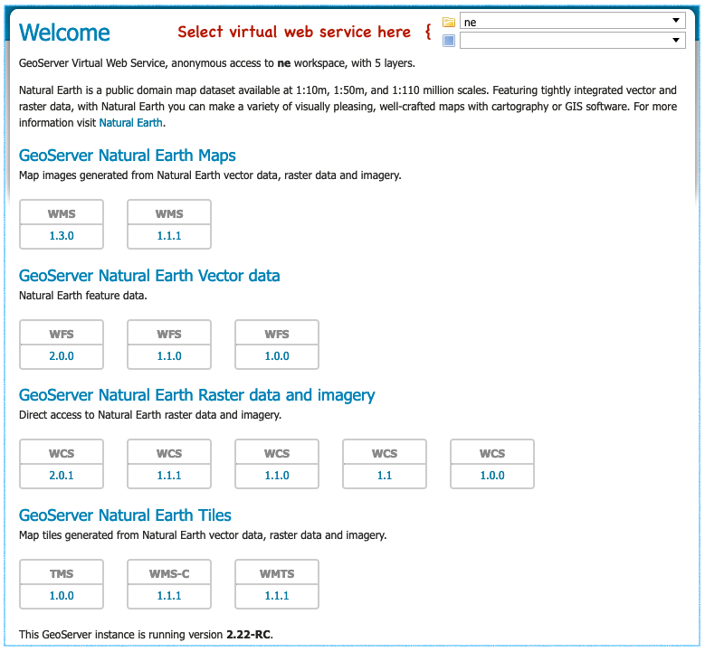
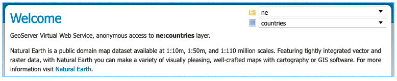
Workspace and Layer Selection
Use the top-right corner of the welcome page to:
- Select workspace to browse workspace web services
- Select layer and layergroup for layer specific web services
You can book mark or share this page (which is great for providing a team or project with its own distinct web services and landing page).
For more information on this functionality see workspace web services and layer web services in the user manual.
Using a workspace virtual web service is great if you are setting up a GIS project, supporting a web application, or providing GIS services for a team. This is especially true as it is straight forward to manage security on a workspace basis.
Using a layer virtual web service is great when registering a layer with a catalogue service such as GeoNetwork. It provides a web service that can only be used to access a single layer.
For the technical background on this feature see Virtual web services in the user manual. This functionality has been present in GeoServer for a long time; but because it required hand editing URLs many users were not aware of capability.
Contact Information and Service Metadata
Contact information now includes a welcome message to be used as introduction on the welcome page for the global services. Editing the contact details for a workspace will override this introduction for visitors viewing the workspace services.
To customize the welcome page header introduction the welcome field is used. To append a welcome page header For more information visit link both organization and online resource are required.
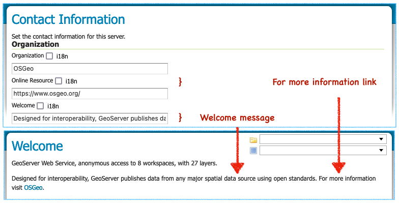
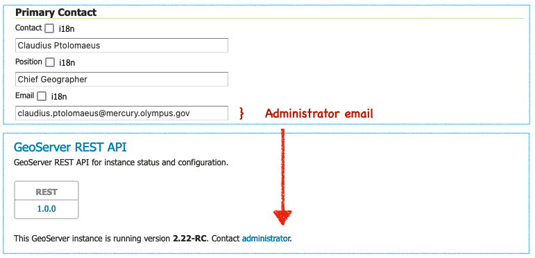
To customize the welcome page footer Contact administrator link contact information for email address is required. If this information is not provided the sentence inviting visitors to contact the administrator will not be shown in the footer.
To customize the service heading and description shown vist a service configuration page. Edit the service title and abstract and the change will be reflected on the welcome page (and in the GetCapabilities document shared with web clients). Disabled services are not available and not listed.
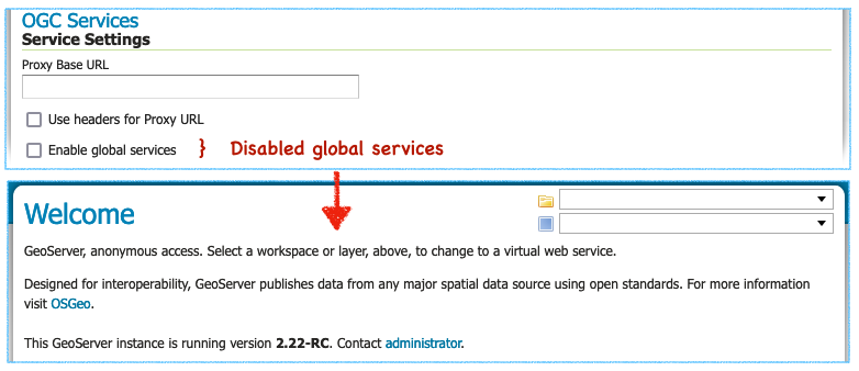
Disabling global services prevents any services from being accessable or listed on the initial welcome page.
All these fields, including the email address, make use of GeoServer internationalization allowing the welcome page to be customized for all your visitors.
For background information visit GSIP-202. Thanks to Jody Garnett and the GeoCat Live product for these improvements.
Startup logging messages
GeoServer performs some initial setup when setting up a data directory for the first time:
- The built-in logging profiles are unpacked into
logs/folder - The
security/folder is setup
In the past this initialization produced some warnings (when checking for files that were not yet created). These warnings were misleading giving the impression that GeoServer was installed incorrectly.
Please note that startup logs now use the CONFIG log level during startup one level lower thatn INFO. This change allows logging profiles to filter out the startup process while still retaining information messages on service operation and use.
Logging profile date formatting updates
The built-in logging profiles have been updated as the date was being incorrectly logged:
-
If you have hand edited any of the built-in logging profiles you can fix the data format manually. Locate appender
PatternLayoutentries and correct the date formatting to%date{dd MMM HH:mm:ss}. -
If you have not modified any of the built-in logging profiles a quick way to update is to remove them from your GEOSERVER_DATA_DIRECTORY
logsfolder.The built-in logging profiles will be restored next time you change profiles or when the application starts up.
-
If you never plan to customize the built-in loggig profiles use the system property
UPDATE_BUILT_IN_LOGGING_PROFILES=true. This setting will cause GeoServer to update the files when changing profiles or on application startup.This setting only affects the built-in logging profiles; any new logging profiles that you have made manually are unaffected.
For more information see the user guide on built-in logging profiles.
Style format
The styles list provides a Format column indicating the format used.
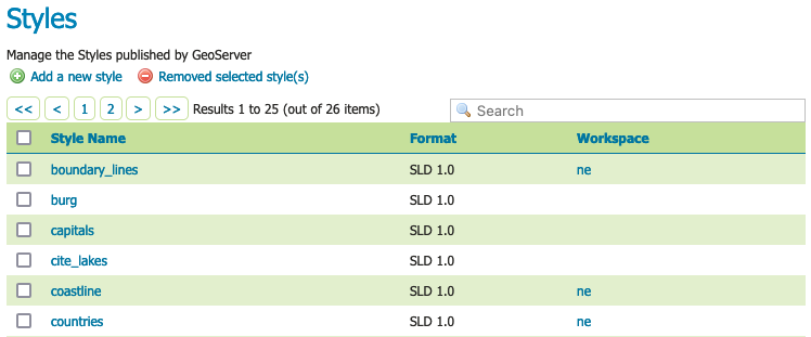
Thanks to Mohammad Mohiuddin Ahmed for this change.
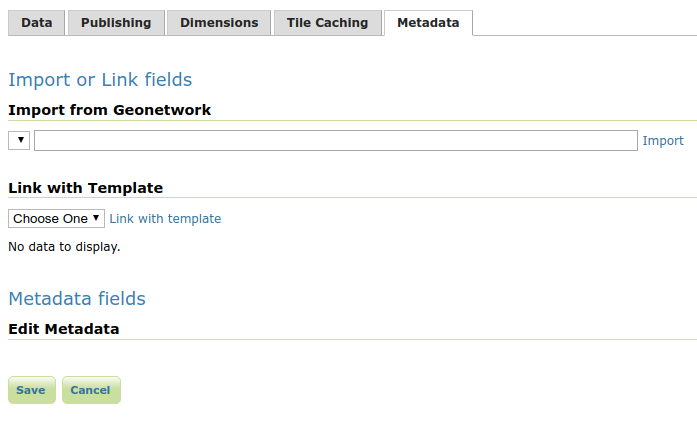
CSW ISO and Metadata extension
To support the use of the CSW module the Metadata extension provides a tab for editing metadata as part of layer configuration. It also provides a REST API for bulk metadata activities including importing from GeoNetwork.
The CSW ISO Metadata profile is now available as an extension.
For background information see GSIP-211.
Thanks to Niels for for this work.
Significant improvements in raster rendering performance
Raster rendering performance has increased significantly for two specific use cases:
- GeoTIFF hyperspectral images, with hundreds of bands, and band interleaved structure
- Mosaicking hundreds of small images
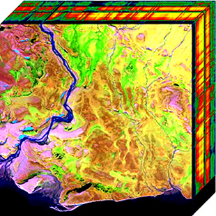
Hyperspectral sensors collect information at a very high spectral resolution, producing images with hundreds of bands. The typical pixel interleaved layout, where all the bands of a single pixel are stored together, is particularly inefficient while rendering a false color image, where only three of them are used. A band interleaved, where each band is stored in a separate bank, is more efficient. GeoServer previously loaded band interleaved images in an inefficient way, but that has been handled, improving both memory usage and rendering performance, in proportion to the number of bands found in the GeoTIFF. For the typical hyperspectral image, that implies an improvement of a couple of orders of magnitude.
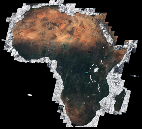
The second use case involves mosaicking hundreds of images, under the notion that each one has a significant number of overviews. Showing the entire mosaick involves opening all these files, fetching the smallest overview, and mosaicking the result: the process used to be slow and very memory intensive (going with the square of the output image size). The implementation has been improved so that the memory used in now linear with the output image size, and the amount of processing has been reduced as well, providing again a couple of orders or magnitude speed up when mosaicking several hundreds small images.
Thanks to Andrea Aime (GeoSolutions) for these improvements.
Community modules news
News about community modules improvements, and new community modules you’ll find in the 2.22.x series.
A reminder that GeoServer community modules are still being worked on and are not directly available for download. If you are interested in these topics please support their completion directly by compiling the source code and contributing; or financially by sponsoring or contracting the development team working on the activity.
COG reader support for Azure
The COG reader community module now supports COGs stored in Azure as well. The location of the COG can be provided as a HTTP(s) link, while eventual access credentials should be provided as system properties:
| System Property | Description |
|---|---|
| azure.reader.accountName | The Azure account name |
| azure.reader.accountKey | The Azure account key |
| azure.reader.container | The Azure container for the blobs |
| azure.reader.prefix | The optional prefix folder for the blobs |
To support this activity contact Daniele (GeoSolutions).
STAC datastore and mosaicking
A new community module, [STAC datastore](https://docs.geoserver.org/latest/en/user/community/stac-datastore/index.html, supports connecting to a STAC catalog implementing the STAC API, and serve collections as vector layers, and items as features in said layers, with full filtering and time dimension support, if the server implements a CQL2 search.
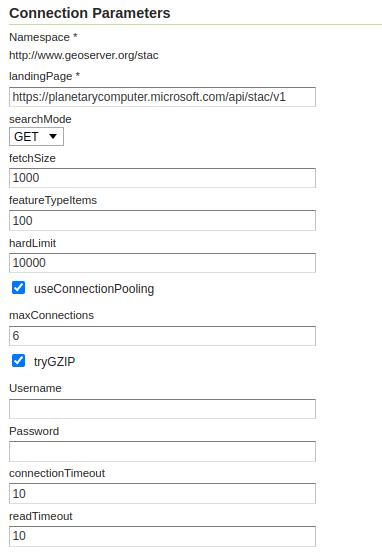
The store can also be used as an index for an image mosaic, if the STAC API assets points to accessible Cloud Optimized GeoTIFFs.
To support this activity contact Andrea (GeoSolutions).
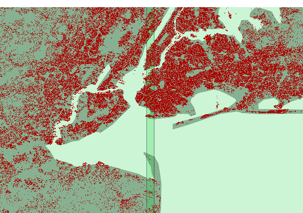
Vector mosaicking datastore
The vector mosaic datastore allows indexing many smaller vector stores (e.g., shapefiles, FlatGeoBuf) and serving them as a single, seamless data source.
An index table is used to organize them, know their location on the file system (or blob storage) and their footprint, along with eventual variables that can be used for quick filtering (e.g., time, collecting organization, and so on).
This can have some advantages compared to the typical database storage:
- Cheaper, when dealing with very large amounts of data in the cloud, as blob storage costs a fraction of an equivalent database.
- Faster for specific use cases, e.g, when extracting a single file and rendering it fully is the typical use case (e.g. tractor tracks in a precision farming application). This happens because the file splitting de-facto imposes and efficient data partitioning, and shapefile access excels at returning the whole set of features (as opposed to a subset).
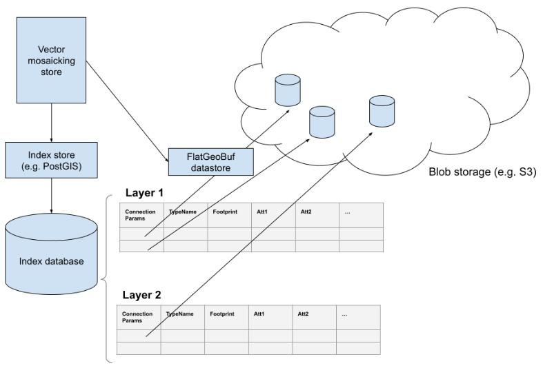
To support this activity contact Andrea (GeoSolutions).
Improvements and Fixes
New Feature:
-
GEOS-10651 Incorporate Vector Mosaic Datastore
-
GEOS-10629 Features Templating - Allow control over encoding of complex attribute with n cardinality
-
GEOS-10610 Selective cache reset on stores and resources, via REST API
-
GEOS-10587 Allow DataStore to auto disable on connection failure
-
GEOS-10524 promote gs-metadata to extension (GSIP 212))
-
GEOS-4613 Expose more JVM statistics on the web gui
-
GEOS-10472 promote gs-csw-iso to extension (GSIP 211)
Improvement:
-
GEOS-10696 Allow configuration of Output Format types allowed in GetFeature
-
GEOS-10677 Improve cleanup of multi part form upload to the dispatcher
-
GEOS-10676 Support uploading .bmp and .gif images as SLD Package icons through restconfig
-
GEOS-10644 Keycloak - Improvements to Role Service
-
GEOS-10639 Keycloak Filter - Allow to use a button to reach keycloak login page
-
GEOS-10637 Keycloak filter configurability improvements
-
GEOS-10581 Support native GeoTIFF band selection
-
GEOS-10580 Server status page improvements for status, modules and docs
-
GEOS-10514 Better capture catalog configuration issues: layergroup with a misconfigured layer
-
GEOS-10505 Display style format as new column in Styles-list, along with Style Name and Workspace
-
GEOS-10501 GetMap: support auth headers forwarding to remote SLD urls
-
GEOS-10495 Request Logger Memory Buffer Limits
-
GEOS-10464 Improve logging and check for NPEs and other issues in Importer Module
For the complete list see 2.22-RC release notes.
About GeoServer 2.22
Release notes: ( 2.22-RC | 2.22-M0 )
- Metadata extension
- CSW ISO Metadata extension
- State of GeoServer (FOSS4G Presentation)
- GeoServer Beginner Workshop (FOSS4G Workshop)
- Welcome page (User Guide)