GeoServer 2.28.0 Release
GeoServer 2.28.0 release is now available with downloads (bin, war, windows), along with docs and extensions.
This is a stable release of GeoServer, recommended for production use. GeoServer 2.28.0 is made in conjunction with GeoTools 34.0, GeoWebCache 1.28.0, ImageIO-Ext 2.0.0, and ImageN 0.9.0.
Thanks to Jody Garnett (GeoCat) for making this release. Thanks to Daniel Calliess, Sören Kalesse and Gabriel Roldan for providing feedback and testing of the 2.28-M0 milestone release.
Security Considerations
This release addresses security vulnerabilities and is considered an important upgrade for production systems.
- GEOS-11777 CVE-2024-45747 Server-Side Template Injection (SSTI) vulnerability in processing FreeMarker templates
- GEOS-11920 CVE-2025-58175 Server-Side Request Forgery (SSRF) Vulnerability in XML entity resolution
- GEOS-11918 CVE-2025-52465 Arbitrary file write vulnerability in Master Password Dump Page
- GEOS-11921 - CVE-2025-21621 - Reflected Cross-Site Scripting (XSS) vulnerability in WMS GetFeatureInfo HTML format (Moderate)
- GEOS-11922 - CVE-2025-58360 - Unauthenticated XXE via WMS GetMap (High)
The use of the CVE system allows the GeoServer team to reach a wider audience than blog posts.
See project security policy for more information on how security vulnerabilities are managed.
Upgrade instructions
Please take note of the Upgrade Instructions, specifically:
-
This release requires Java 17 LTS minimum, Java 11 is no longer supported.
GeoServer is tested with Long Term Support releases: Java 17 LTS and Java 21 LTS. For more information see Java Considerations in the user manual.
-
The global setting Unrestricted XML External Entity Resolution has been replaced with the
ENTITY_RESOLUTION_UNRESTRICTEDapplication property.This change primarily affects application schema users that have not yet adopted
ENTITY_RESOLUTION_ALLOWLIST. See update instructions for details. -
Due to a user interface change, it is no longer necessary to generate a masterpw.info when upgrading an older data directory.
If this file is present from an earlier upgrade, it is still considered a security warning and is noted on the welcome page.
Image Processing Engine updated
Updating the image processing engine used by GeoServer to be Java 17 compatible is one of the first major objectives of the GeoServer 3 crowdfunding activity. We are pleased to provide the upgrade from Java Advanced Imaging 1.1.3 to Eclipse ImageN 0.9.0 as part of the GeoServer 2.28.0 release.
Eclipse ImageN 0.9.0 is a stable release of two established codebases (Java Advanced Imaging and JAI-Ext) combined together into a single project. ImageN 1.0.0 will be released once the team has had an opportunity to increase the test coverage and update the user manual, over the course of the GeoServer 3.0 series.
Thanks to Jody (GeoCat), Andrea and Daniele (GeoSolutions) for this work and GeoServer 3 Crowdfunding for accomplishing this key objective for the future of GeoServer. We would also like to thank the Eclipse Foundation for working with Oracle to finally make this Sun Microsystems technology open source, alongside OpenJDK.
For more information see Eclipse ImageN and updated Wikipedia Entry for Java Advanced Imaging.
Attribute Restrictions
Layer Feature Type Details has received a major improvement with an Edit attribute dialog making it easier to define the attribute name, description, type, nillability and for the first time restrictions. Attribute restrictions are used limit data values and are included in DescribeFeatureType.
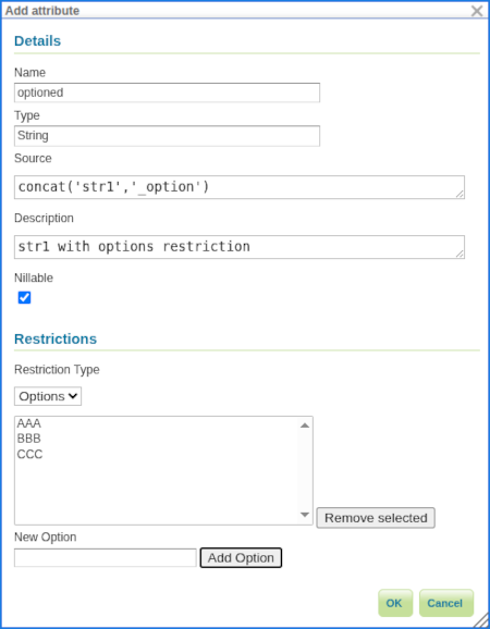
Two types of restrictions are available:
- Options: Used to restrict set of numeric or string values to a provided set.
- Range: Used to restrict numeric values between a minimum inclusive and maximum inclusive limit.
Thanks to Alessandro Ricchiuti (GeoSolutions) for this powerful improvement.
For more information see Feature Type Details in the User Manual.
- GSIP-234 Advertise and Enforce Attribute Restrictions
- GEOS-11937 GSIP 234 - Advertise and Enforce Attribute Restrictions
Legend: Symbology Encoding Functions
This release includes a long-awaited improvement for legend graphic generation - creating a legend graphic when the Symbology Encoding Recode, Interpolate and Categorize functions are used.
<Fill>
  <CssParameter name="fill">
    <ogc:Function name="Recode">
      <!-- Value to Transform -->
      <ogc:Function name="strTrim">
        <ogc:PropertyName>SUB_REGION</ogc:PropertyName>
      </ogc:Function>
      <!-- Map of input to output values -->
      <ogc:Literal>N Eng</ogc:Literal>   <ogc:Literal>#6495ED</ogc:Literal>
      <ogc:Literal>Mid Atl</ogc:Literal> <ogc:Literal>#B0C4DE</ogc:Literal>
      <ogc:Literal>S Atl</ogc:Literal>   <ogc:Literal>#00FFFF</oac:Literal>
      <ogc:Literal>E N Cen</ogc:Literal> <ogc:Literal>#9ACD32</ogc:Literal>
      <ogc:Literal>E S Cen</ogc:Literal> <ogc:Literal>#00FA9A</ogc:Literal>
      <ogc:Literal>W N Cen</ogc:Literal> <ogc:Literal>#FFF8DC</ogc:Literal>
      <ogc:Literal>W S Cen</ogc:Literal> <ogc:Literal>#F5DEB3</ogc:Literal>
      <ogc:Literal>Mtn</ogc:Literal>     <ogc:Literal>#F4A460</ogc:Literal>
      <ogc:Literal>Pacific</ogc:Literal> <ogc:Literal>#87CEEB</ogc:Literal>
    </ogc:Function>
  </CssParameter>
</Fill>
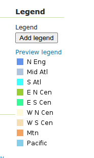
Thanks to Andrea Aime (GeoSolutions) for this improvement on behalf of German Aerospace Center (DLR).
- GEOS-8002 LegendGraphic display using transformation functions (recode, interpolate, categorize)
OAuth2 OpenID Connect community modules
A new community module sec-oidc is now available based directly on Spring Security Core. This new community module is intended as a direct replacement for the existing sec-oauth2-geonode, sec-oauth2-github, sec-oauth2-google, and sec-oauth2-openid-connectplugins which have reached end of life.
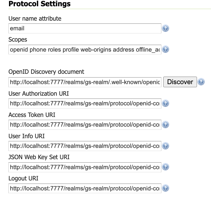
For more information see OAUTH2 OIDC in the user manual. Extensive information (and notes) are provided for working with Google, GitHub, Microsoft Azure, and Keycloak. We are really pleased that the new OIDC community plugin is available alongside the existing OAuth2 implementations for comparison and testing.
The initial work was performed by Andreas Watermeyer (ITS Digital Solutions), and completed for GeoServer 2.28.0 by David Blasby (GeoCat), Ian Turton, and Alessio Fabiani (GeoSolutions). Thanks to the GeoServer 3 Crowdfunding sponsors for supporting this important development.
Developer Updates
A number of significant changes affect developers working on the GeoServer codebase:
-
The change to Java 17 LTS minimum brings new language features to the codebase
-
Java 17 build improvements
-
Maven bill-of-materials import to manage both GeoTools library modules and syncrhonize third-party dependencies with the GeoTools project.
Thanks to Gabriel Roldan (Camptocamp) for working on these activities on behalf of GeoServer 3 sponsors.
Release notes
New Feature:
- GEOS-11937 GSIP 234 - Advertise and Enforce Attribute Restrictions
- GEOS-11949 Support MS Excel download from WPS-download
- GEOS-11800 Implement GeoServer WPS SpatioTemporalZonalStatistics process
- GEOS-11911 Application property ROOT_LOGIN_ENABLED
- GEOS-8002 LegendGraphic display using transformation functions (recode, interpolate, categorize)
Improvement:
- GEOS-11934 Image processing tile cache: better logging and deeper cleanups
- GEOS-11788 Apply feedback from CSP testing
- GEOS-11833 Unnecessary antiCache parameter on some GUI images
- GEOS-11837 MapML Support for LayerGroups
- GEOS-11867 Improve entity resolution
- GEOS-11892 Column mentioning user that performed last modification for layers and stores list UI
- GEOS-11938 Add support for property selection in OGC API Features
Bug:
- GEOS-11823 Quality Degradation in Scanned Map Rendering (GeoServer 2.25.3 onward)
- GEOS-11944 GetLegendGraphic Fails When Using RasterSymbolizer With Interval ColorMap And ENV variables
- GEOS-11946 DirectRasterRenderer may fail on creating AlphaBand from ROI using Lookup
- GEOS-11957 Cannot logout due remember-me cookie with oidc
- GEOS-10728 Cannot download GeoPackage if the source data contains UUID types
- GEOS-11274 Cannot get a JSON legend with an external reference to a non published directory
- GEOS-11620 Smart Data Loader plugin for GeoServer 2.26 produces a Mapping file data source definition and tries to establish a connection pool, but fails
- GEOS-11688 After restart unable to load External Style SLD when requesting multiple tiles
- GEOS-11708 STAC breadcrumbs rendering as plain text
- GEOS-11751 Symbolizer URL in GetLegendGraphic JSON Request is Broken
- GEOS-11808 Attribute names containing characters the XML Encoder can’t handle are accepted for input, causing errors
- GEOS-11832 count=0 service exception for some formats
- GEOS-11857 Random NPE In LocalWorkspaceCallback
- GEOS-11860 MapML does not match raster rendering geometry simplification behavior
- GEOS-11862 Layer Preview and Tile Layers page dropdown links broken after updating table
- GEOS-11863 Use GetTile or GetMap requests in
for cached raster coverages where appropriate - GEOS-11865 MapDownloadProcess washes out 1 band gray images when transparency is on
- GEOS-11866 Prevent requests setting variables that should only be set by GeoServer
- GEOS-11879 Xalan causes a java.lang.NoClassDefFoundError
- GEOS-11902 More compact, easier to maintain conformance configuration UI
- GEOS-11910 JMS Cluster settings Section is not showing properly
- GEOS-11917 INSPIRE configuration does not get properly saved when OGC API module is included
- GEOS-11931 GeoServer binary package fails to start after Jetty 9.x to 10.0.25 upgrade
Task:
- GEOS-11848 Migrate use of JAITools to JAI-Ext
- GEOS-11956 Fix build server WfsCompatibilityTest failure (when testing against “local” GeoServer on port 8080)
- GEOS-11813 Create REST API For Security Providers
- GEOS-11814 Create a REST API for Filter Chains
- GEOS-11815 Create authentication filter REST API
- GEOS-11831 OseoDispatcherCallback improvements
- GEOS-11852 Remove master password info page
- GEOS-11853 Clarify keystore vs master vs root password
- GEOS-11854 Generation of security/masterpw.info no longer required
- GEOS-11855 global settings cog warning in release data directory
- GEOS-11869 Replace entity resolution setting with application property
- GEOS-11881 Update postgis-jdbc
- GEOS-11882 Cleanup postgis-jdbc dependencies
- GEOS-11932 Upgrade Oracle JDBC driver to Java 17
For the complete list see 2.28.0 release notes.
Community Updates
Community module development:
- GEOS-11951 Add PMTiles DataStore community module for reading Protomaps vector tiles
- GEOS-11816 Features templating OGC API fetch by ID fails
- GEOS-11819 Make smart data loader skip unsupported column types
- GEOS-11822 OGC API procesess basic implementation
- GEOS-11829 Features templating ability to override schema
- GEOS-11839 New Community Module for WPS Download in NetCDF output format for spatiotemporal coverages
- GEOS-11870 Singlestore(MemSql) datastore community module
- GEOS-11885 Smart Data Loader does not support postgresql UUID data type
- GEOS-11887 Features Templating does not returns content type and charset header on OGC-API
Community modules are shared as source code to encourage collaboration. If a topic being explored is of interest to you, please contact the module developer to offer assistance.
Developer updates
- GEOS-11845 GSIP-232 Upgrade GeoServer and GeoWebCache Build to Java 17
- GEOS-11943 remove PDF generation of manual from build process
- GEOS-11952 GeoServer 2.28.0 Release cleanup
- GEOS-11836 Upgrade ErrorProne to 2.31.0
- GEOS-11843 Use Spring framework BOM to manage Spring and Spring Security dependencies
- GEOS-11851 Remove unnecessary javac lint suppressions
- GEOS-11858 Update to PMD 7.14 and enable unnecessary suppression rule
About GeoServer 2.28 Series
Additional information on GeoServer 2.28 series:
- GeoServer 2.28 User Manual
- Advertise and Enforce Attribute Restrictions
- GeoServer 2025 Q4 Developer Update
GeoServer is an Open Source Geospatial Foundation project supported by a mix of volunteer and service provider activity. We reply on sponsorship to fund activities beyond the reach of individual contributors.