GeoServer 2.27.3 Release
GeoServer 2.27.3 release is now available with downloads (bin, war, windows), along with docs and extensions.
This is a maintenance release of GeoServer providing existing installations with minor updates and bug fixes. GeoServer 2.27.3 is made in conjunction with GeoTools 33.3, and GeoWebCache 1.27.3.
Thanks to Jody Garnett (GeoCat) for making this release.
Security Considerations
This release addresses security vulnerabilities and is an important upgrade for production systems.
- GEOS-11920 CVE-2025-58175 Server-Side Request Forgery (SSRF) Vulnerability in XML entity resolution
- GEOS-11918 CVE-2025-52465 Arbitrary file write vulnerability in Master Password Dump Page
See project security policy for more information on how security vulnerabilities are managed.
Upgrade instructions
Please take note of the Upgrade Instructions, specifically:
-
The global setting Unrestricted XML External Entity Resolution has been replaced with the
ENTITY_RESOLUTION_UNRESTRICTEDapplication property.This change primarily affects application schema users that have not yet adopted
ENTITY_RESOLUTION_ALLOWLIST. See update instructions for details. -
Due to a user interface change, it is no longer necessary to generate a masterpw.info when upgrading an older data directory.
If this file is present from an earlier upgrade, it is still considered a security warning and is noted on the welcome page.
Attribute Restrictions
Layer Feature Type Details has received a major improvement with an Edit attribute dialog making it easier to define the attribute name, description, type, nillability and for the first time restrictions. Attribute restrictions are used limit data values and are included in DescribeFeatureType.
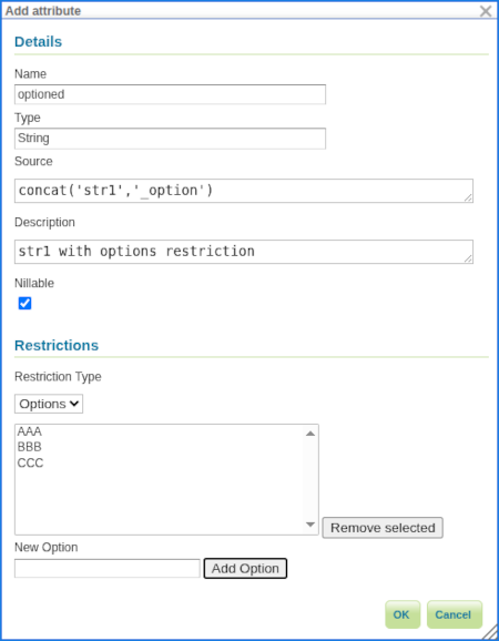
Two types of restrictions are available:
- Options: Used to restrict set of numeric or string values to a provided set.
- Range: Used to restrict numeric values between a minimum inclusive and maximum inclusive limit.
Thanks to Alessandro Ricchiuti (GeoSolutions) for this powerful improvement.
For more information see Feature Type Details in the User Manual.
- GSIP-234 Advertise and Enforce Attribute Restrictions
- GEOS-11937 GSIP 234 - Advertise and Enforce Attribute Restrictions
Legend: Symbology Encoding Functions
This release includes a long-awaited improvement for legend graphic generation - creating a legend graphic when the Symbology Encoding Recode, Interpolate and Categorize functions are used.
<Fill>
  <CssParameter name="fill">
    <ogc:Function name="Recode">
      <!-- Value to Transform -->
      <ogc:Function name="strTrim">
        <ogc:PropertyName>SUB_REGION</ogc:PropertyName>
      </ogc:Function>
      <!-- Map of input to output values -->
      <ogc:Literal>N Eng</ogc:Literal>   <ogc:Literal>#6495ED</ogc:Literal>
      <ogc:Literal>Mid Atl</ogc:Literal> <ogc:Literal>#B0C4DE</ogc:Literal>
      <ogc:Literal>S Atl</ogc:Literal>   <ogc:Literal>#00FFFF</oac:Literal>
      <ogc:Literal>E N Cen</ogc:Literal> <ogc:Literal>#9ACD32</ogc:Literal>
      <ogc:Literal>E S Cen</ogc:Literal> <ogc:Literal>#00FA9A</ogc:Literal>
      <ogc:Literal>W N Cen</ogc:Literal> <ogc:Literal>#FFF8DC</ogc:Literal>
      <ogc:Literal>W S Cen</ogc:Literal> <ogc:Literal>#F5DEB3</ogc:Literal>
      <ogc:Literal>Mtn</ogc:Literal>     <ogc:Literal>#F4A460</ogc:Literal>
      <ogc:Literal>Pacific</ogc:Literal> <ogc:Literal>#87CEEB</ogc:Literal>
    </ogc:Function>
  </CssParameter>
</Fill>
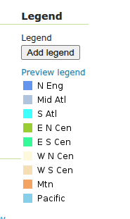
Thanks to Andrea Aime (GeoSolutions) for this improvement on behalf of German Aerospace Center (DLR).
- GEOS-8002 LegendGraphic display using transformation functions (recode, interpolate, categorize)
Release notes
New Feature:
- GEOS-11911 Application property ROOT_LOGIN_ENABLED
- GEOS-11937 GSIP 234 - Advertise and Enforce Attribute Restrictions
- GEOS-11949 Support MS Excel download from WPS-download
- GEOS-8002 LegendGraphic display using transformation functions (recode, interpolate, categorize)
Improvement:
- GEOS-11867 Improve entity resolution
- GEOS-11892 Column mentioning user that performed last modification for layers and stores list UI
- GEOS-11914 Using namespaces parameter with virtual services does not work
- GEOS-11938 Add support for property selection in OGC API Features
- GEOS-11950 WMS cascade: fully respect ‘restrict to layer bounds’ flag on GetMap requests
Bug:
- GEOS-4159 Layer from SQL view feature type details not refreshing after editing sql query (and refreshing attributes there)
- GEOS-11896 WPS map download flips east/west coordinates
- GEOS-11900 CRS:XY syntax builds isolated CRSs that do not leverage the EPSG database transformation library
- GEOS-11902 More compact, easier to maintain conformance configuration UI
- GEOS-11910 JMS Cluster settings Section is not showing properly
- GEOS-11917 INSPIRE configuration does not get properly saved when OGC API module is included
- GEOS-11944 GetLegendGraphic Fails When Using RasterSymbolizer With Interval ColorMap And ENV variables
- GEOS-11946 DirectRasterRenderer may fail on creating AlphaBand from ROI using Lookup
Task:
- GEOS-11813 Create REST API For Security Providers
- GEOS-11814 Create a REST API for Filter Chains
- GEOS-11815 Create authentication filter REST API
- GEOS-11852 Remove master password info page
- GEOS-11853 Clarify keystore vs master vs root password
- GEOS-11854 Generation of security/masterpw.info no longer required
- GEOS-11869 Replace entity resolution setting with application property
- GEOS-11881 Update postgis-jdbc
- GEOS-11898 GeoFence: issues in evaluation of virtual layer services access
- GEOS-11956 Fix build server WfsCompatibilityTest failure (when testing against “local” GeoServer on port 8080)
For the complete list see 2.27.3 release notes.
Community Updates
Community module development:
- GEOS-11885 Smart Data Loader does not support postgresql UUID data type
- GEOS-11887 Features Templating does not returns content type and charset header on OGC-API
- GEOS-11888 Features Templating does not support CQL2 new syntax
- GEOS-11961 OSEO layer management: Support creation of image mosaics in CRS other than 4326
Community modules are shared as source code to encourage collaboration. If a topic being explored is of interest to you, please contact the module developer to offer assistance.
About GeoServer 2.27 Series
Additional information on GeoServer 2.27 series:
- GeoServer 2.27 User Manual
- CITE Certification achieved
- GeoServer 2025 Q2 Developer Update
- GeoServer 2025 Roadmap
- Content-Security-Policy Headers
- OGCAPI Features Extension
- File system access isolation
- Promote data dir catalog loader to core
- Advertise and Enforce Attribute Restrictions
GeoServer is an Open Source Geospatial Foundation project supported by a mix of volunteer and service provider activity. We reply on sponsorship to fund activities beyond the reach of individual contributors.