GeoServer Blog
GeoServer 2.14.3 Released
| We are happy to announce the release of GeoServer 2.14.3. Downloads are provided (zip | war | exe) along with docs (html | pdf) and extensions. |
This is a maintenance release of the GeoServer 2.14 series and is recommended for all production systems. Users of prior releases of GeoServer are encouraged to upgrade.
This release is made in conjunction with GeoTools 20.3 and GeoWebCache 1.14.3. Thanks to all who contributed to this release.
| For more information please see our release notes (2.14.3 | 2.14.2 | 2.14.1 | 2.14.0 | 2.14-RC). |
Improvements and Fixes
This release includes a number of new features and improvements, including:
-
Fix user creation failing on REST API
-
OpenLayers 3 preview did not work on projected data when using version 1.3 of the WMS protocol
-
Fixed style editor HTML issues when going back from full screen editor mode, and fixed moving styles referring to local icons from global to workspace
-
NetCDF extension packaging fix, allows it to run without also having the NetCDF out plugin installed
-
Assorted fixes in WMTS workspace specific capabilities document generation
About GeoServer 2.14 Series
Additional information on the GeoServer 2.14 series:
-
New MongoDB extension added
-
Style editor improvements including side by side editing
-
Nearest match support for WMS dimension handling
-
Upgrade notes documenting REST API feature type definition change
-
State of GeoServer 2.14 (SlideShare)
-
GeoServer Ecosystem (SlideShare)
-
GeoServer Developers Workshop (SlideShare)
GeoServer 2.15.0 Released
| The GeoServer team is happy to announce the GeoServer 2.15.0 release with downloads (zip | war | exe), documentation (html | pdf) and extensions. |
This release is production ready and is ready to work with your Java 8 or Java 11 operational environment. This release is made in conjunction with GeoWebCache 1.15.0 and GeoTools 21.0.
The ability to work with Java 11 is the result a dedicated code sprint. Thanks to organizations participating in the code sprint (Boundless, GeoSolutions, GeoCat, Astun Technology, CCRi) along with sprint sponsors (Gaia3D, atol, osgeo:uk, Astun Technology).
Layer Service Settings
To start things off an often requested capability, the ability to control which services are enabled on a layer-by layer basis.
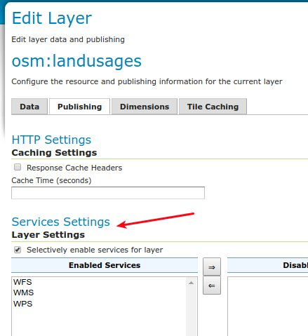
To try it our yourself see Service Settings in our user manual.
GeoFence Internal Server Extension
Originally a standalone service offering fine grain control over GeoServer security this functionality has been packaged up and embedded into a GeoServer extension for easier deployment.
-
GeoFence rules provided greater control over security allowing layer by layer service restrictions
-
GeoFence rules can provide access to data overriding layer details including CQL filter to limit contents returned and default style used for rendering
-
GeoFence rules can limit access to a geographic extent
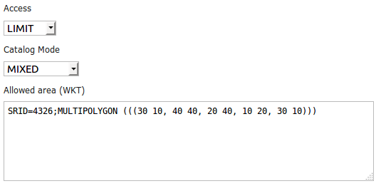
For more details see GeoFence Internal Server in our user manual.
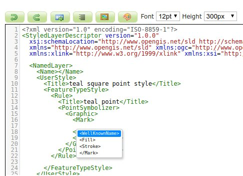
Style Editor SLD Auto-Complete
To help make editing easier the Style Editor can provide auto-complete suggestions for SLD 1.0. To try it out yourself use control-space for context aware suggestions.
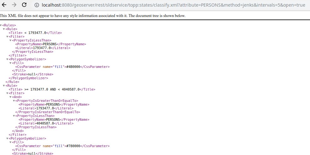
Generate Classified Thematics maps
SLDService is now an official extension, with a number of improvements. SLDService can now be used for the
-
classification of raster data too
-
equal area classification
-
standard deviation filtering
The SLD REST Service extension is used to generate thematic styles based on attribute data:
curl -v -u admin:geoserver -XGET
  http://localhost:8080/geoserver/rest/sldservice/states/classify.xml
  ?attribute=PERSONS
  &ramp=CUSTOM
  &method=quantile
  &intervals=3
  &startColor=0xFF0000
  &endColor=0x0000FF
  &open=true
For more information see SLD Rest Service in our user manual.
WPS GetExecutionStatus and Dismiss Operations
WPS “GetExecutions” vendor operation allows each user to get the list of running processes:
-
Users can review all their running processes
-
Administrators can see all processes
The Dismiss vendor operation can be used to cancel the execution of one of the listed processes.
For more information see Dismiss in our user guide.
Java 11 Support
The provided binary download works with either Java 8 or Java 11. Tomcat 9 or newer is required for the WAR install. The user guide compatibility list will continue to be updated based on your feedback.
The java ecosystem is now being led by the open source OpenJDK project, with long term support available from a range of organizations notably RedHat OpenJDK and Adopt OpenJDK. The GeoTools user guide provides an overview of Java 8 and Java 11 distributions.
The net effect of these changes:
-
If you have been using Oracle JDK please review your options
-
Java 8 will continue to be available
-
The Java ecosystem is now led by the open-source Open JDK project
Java 11 no longer supports the Java 2 extension mechanism used for native JAI and native ImageIO libraries. We recommend the use of the pure Java JAI-EXT operations which have been made the default (see the next section).
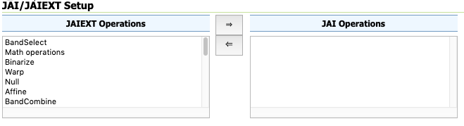
JAI-EXT operations on by default
The use of the JAI-EXT operations have long been a recommendation, with this release we are making them the default for GeoServer. The JAI-EXT library offers a pure java implementation enhanced for geospatial functionality supporting NODATA pixels and support for vector footprints.
GeoServer Codebase
In addition to Java 11 support this release includes:
-
Add JSON as a Legend Output format (GISP 173)
-
Printing plugin upgrade version of JTS
-
Upgrade NetCDF dependencies
-
Improvements for vector tile production, both in terms of output correctness and production performance
Thanks to Andrea Aime for steady work on the codebase quality:
-
PMD source code analysis, high priority checks, will fail the build in case of issues
-
Error Prone byte code analysis, same as above
-
Many small bugs fixed
For more details developers are invited to review Automated Quality Assurance checks in our developers manual. Also, work in ongoing on the master (dev) branch to extend the reach of static code checks using SpotBugs and CheckStyle too.
About GeoServer 2.15 Series
Additional information on the GeoServer 2.15 series:
-
Release Notes (2.15.0 2.15-RC 2.15-M0) - Running on Java 11 (User Manual)
GeoServer 2.15-RC Released
| We are happy to share a GeoServer 2.15-RC milestone release with downloads (zip | war | exe), documentation (html | pdf) and extensions. |
This release candidate is provided for everyone considering a Java 11 operational environment in 2019. A release candidate provides a final to support the development team with early feedback: your assistance and participation is requested!
This release is a result of participation in the OSGeo Java 2018 Code Sprint and is made in conjunction with GeoTools 21-RC and GeoWebCache 1.15-RC. We would like to thank organizations participating in the code sprint (Boundless, GeoSolutions, GeoCat, Astun Technology, CCRi) along with sprint sponsors (Gaia3D, atol, osgeo:uk, Astun Technology). Our gratitude goes out to the individuals who worked so hard to bring everything together.
Highlights
In addition to Java 11 support this release includes:
-
JAI-EXT enabled by default, in other words, support for NODATA pixels on by default
-
Add JSON as a Legend Output format (GISP 173)
-
Printing plugin upgrade version of JTS
-
SLDService become an official extension, with a number of improvements in it SLDService (classification of raster data too, equal area classification, standard deviation filtering)
-
Allow configuring services on a per layer basis
-
GeoFence upgraded from community module to official extension
-
WPS “GetExecutions” vendor operation allows each user to get the list of running processes (limited to his account for normal users, showing all processes if the request is made by an admin)
-
Autocomplete support for SLD 1.0 in style editor
-
Improvements for vector tile production, both in terms of output correctness and production performance
-
Upgrade NetCDF dependencies
-
QA work adding PMD and ErrorProne checks in the build
-
and a large number of bug fixes.
Java 11 Support
The provided binary download works with either Java 8 or Java 11. Tomcat 9 or newer is required for the WAR install.
We will the update the user guide compatibility list based on your feedback and testing of this 2.15-RC milestone release. Please note that Java 11 no longer supports the Java 2 extension mechanism used for native JAI and native ImageIO.
This is a good opportunity to review your operational environment and help test GeoServer with the environment you intend to use in 2019.
Java Roadmap Considerations
Our initial concerns with respect to continued availability of the Java 8 platform have been alleviated by industry action and commitment. Extensive Java 8 support options are now available, with RedHat making a public commitment to contribute fixes to the OpenJDK 8 codebase, and a range of organizations committed to making OpenJDK 8 builds available on a range of platforms.
Oracle has changed to a six month release schedule, donating additional components to OpenJDK to make it lead platform. Long term support (beyond six months) is being offered from a range of organizations notably RedHat OpenJDK and Adopt OpenJDK.
The net effect of these changes:
-
If you have been using Oracle JDK up until now it is time to review your options
-
Java 8 will continue to be available
-
The Java ecosystem is now led by the open-source Open JDK project
See the GeoTools user guide for a table outlining the Java 8 and Java 11 alternatives to consider in the year ahead.
About GeoServer 2.15 Series
Additional information on the GeoServer 2.15 series:
-
Release Notes (2.15-RC)
-
Release Notes (2.15-M0)
-
Running on Java 11 (User Manual)
GeoServer 2.14.2 Released
| We are happy to announce the release of GeoServer 2.14.2. Downloads are provided (zip | war | exe) along with docs (html | pdf) and extensions. |
This is a stable release of the GeoServer 2.14 series and is recommended for all production systems. Users of prior releases of GeoServer are encouraged to upgrade.
This release is made in conjunction with GeoTools 20.2 and GeoWebCache 1.14.2. Thanks to all who contributed to this release.
| For more information please see our release notes (2.14.2 | 2.14.1 | 2.14.0 | 2.14-RC). |
Improvements and Fixes
This release includes a number of new features and improvements:
-
WMTS Restful binding is now accessible to all users (used to be limited to admins) and works with workspace specific services
-
gs:DownloadEstimator (almost always) returns true when estimating full raster downloads at native resolution
-
Cannot create jp2k coverage through rest (IndexOutOfBounds)
-
KML ignores sortBy parameter when querying records
-
NullPointerException when using env() function with LIKE operator in CSS filters
-
Can’t modify existing GWC blobstore via UI without renaming
-
NPE if a Jiffle Rendering Transformation is used with Channel Selection
-
OpenLayers2 preview does not trigger automatically on IE8
-
Bad rendering with JAI-EXT and Input/Output TransparentColor options
-
Complex MongoDB generated properties are not correctly handlded in SLDs
-
Move the GeoServer ENV Parametrization documentation to a more general Section
-
Allow expressions in ColorMapEntry labels for GetLegendGraphic
About GeoServer 2.14 Series
Additional information on the GeoServer 2.14 series:
-
New MongoDB extension added
-
Style editor improvements including side by side editing
-
Nearest match support for WMS dimension handling
-
Upgrade notes documenting REST API feature type definition change
-
State of GeoServer 2.14 (SlideShare)
-
GeoServer Ecosystem (SlideShare)
-
GeoServer Developers Workshop (SlideShare)
Java 2018 Code Sprint Results
The Java 2018 code sprint was an ambitious event gathering up OSGeo Java projects to look at Java 11 compatibility. With a great response from the GeoServer community we are pleased to announce the GeoServer can now run in Java 11!
This sprint was an important response by our community to changes in the Java roadmap. The immediate motivation is to give our users the option of using Java 11 in the coming year now that OpenJDK is taking over as lead project. We are also pleased to report that Java 8 will continue to be supported (thanks to the commitment of RedHat and Adopt OpenJDK) giving everyone a chance to migrate when ready.
We had 11 participants for the sprint - thanks to everyone who attended!
-
David Vick (Boundless), Devon Tucker (Boundless), Jim Hughes (CCRi), Jody Garnett (Boundless) Kevin Smith (Boundless), and Torben Barsballe (Boundless) gathered at the Boundless office in Victoria, Canada.
-
Andrea Aime (GeoSolutions) and Antonello Andrea (Hydrologis) participated from Andrea’s home office in Italy.
-
María Arias de Reyna (GeoCat), Ian Turton (Astun), Landon Blake (BKF Engineers), and Brad Hards participated remotely.
With support from OSGeo and event sponsors many individuals were able to meet up in person, with those hosed at the Boundless Victoria office enjoying the occasional break outside.

How to try it out:
To get started:
-
Download and install Java 11 from jdk.java.net/11
-
Download the GeoServer 2.15-M0 milestone release of GeoServer
* The GeoServer 2.15-M0 will run under Java 11 with no additional configuration on **Tomcat 9** or newer and **Jetty 9.4.12** or newer.


* The binary distribution includes a compatible version of Jetty.
We need your help:
-
pulling together running on java 11 instructions for additional application servers, please download the WAR bundle to help out
-
testing the windows installer
Sponsors
Thanks to Gaia3D for leading with a silver sponsorship, and ASTUN Technology, OSGeo:UK, and ATOL for their bronze sponsorships.


![]()
These sprints also require people to function, and we appreciate Boundless, GeoCat, ASTUN Technology, GeoSolutions and CCRi for their in-kind participation.
![]()


Key accomplishments:
-
GeoServer was upgraded to Spring 5. Thanks to David Vick and everyone for this (especially the Spring Security upgrade with James).
-
Kevin went through the same steps for GeoWebCache for a difficult couple of days.
-
The EMF models that drive much of our parsing technology were upgraded. Thanks to Ian who worked through this, putting us in a much better spot to make changes to our codebase.
-
Torben helped remove countless references to internal “com.sun” classes.
-
A big thanks to Andrea for stepping up where needed (i.e. everywhere) and encouraging everyone through out the week
-
Thanks to Andrea and Brad for preliminary work that made this sprint possible.
-
Thanks to Jody for doing the milestone release.

Outstanding issues:
Certain components and dependencies could not be upgraded as no Java 11-compatible versions have been released. These have been removed or replaced by different libraries where possible, but some incompatible libraries remain.
The remaining issues are primarily either Internal API usage or Illegal access. These will only cause problems when running on Java 11:
Internal API usage
Some components and dependencies reference internal Java API. Depending on the nature of this API, calling this code may cause a runtime error or a warning when running on Java 11. If you run into any unusual failures when running under Java 11, please report them.
Examples of libraries producing these warnings:
-
freemarker template library (used for GetFeatureInfo responses)
-
ehcache library used for image mosaic performance
-
Java Advanced Imaging used for image processing
Illegal Access
Java 11 introduces stricter access constraints on reflective operations. For now, such issues will only cause a warning in the logs, of the form:
WARNING: Illegal reflective access by ...
In future versions of Java, this will instead cause a runtime error.
Known warnings you can expect when running in Java 11:
-
org.hsqldb.persist.RAFileNIO
-
org.parboiled.transform.AsmUtils
-
org.fest.reflect.util.Accessibles
-
com.google.protobuf.UnsafeUtil
-
net.sf.cglib.core.ReflecUtils
If you run into a reflective access warning about a package not in this list, please report it.
Community Modules
The following community modules do not yet support Java 11:
-
printing
-
script
-
spatiallite
-
monitor-hibernate