GeoServer Blog
GeoServer 2.18-RC Release Candidate
The GeoServer community is pleased to share the availability of GeoServer 2.18-RC Release Candidate for testing. Downloads are available (zip and war) along with documentation and more than 40 extensions.
This is a GeoServer release candidate made in conjunction with GeoTools 24-RC and GeoWebCache 1.18-RC.
- Release candidates are a community building exercise and are not intended for production use.
- We ask the community (everyone: individuals, organizations, service providers) to download and thoroughly test this release candidate and report back.
- Participating in testing release candidates is a key expectation of our open source social contract. We make an effort to thank each person who tests in our release announcement and project presentations!
We would like to thank everyone who contributed to this release. Jody Garnett (GeoCat) for this release candidate downloads and setting up the 2.18.x branch.
Release Candidate Testing Priorities
We would like to ask for your assistance testing the following:
- The number one testing priority is to try out GeoServer with your data! Mass market open source thrives on having many people to review. Data driven open source like GeoServer thrives on exposure to many datasets.
- The rest of this blog post highlights new features for GeoServer 2.17, please try out these features, read the documentation links, and ask questions.
Thanks to Jukka Rahkonen and Brad Hards for initial testing. To add your name to the list for the 2.18 release announcement: download the release candidate, try it out, and let us know (on the user list, twitter, or LinkedIn).
Black Lives Matter
The casual use of the word “slave” in computer software is an unnecessary reference to a painful human experience that continue to impact society.
- Change to the use of primary / replica in description of GeoServer clustering (although new diagrams would be welcome)
- Change to use of allow-list / deny-list
- Changed to use of keystore password
- Changing our repository to a “main” branch will be scheduled when both the git command line tool and GitHub repository infrastructure roll out planned improvements for a seamless transition.
David Blasby (GeoCat) worked on this issue as part of the OSGeo Bolsena 2020 Work-from-home code-sprint.
User interface creature comforts
A couple small but important changes to the GeoServer user interface make a significant difference to how you interact with the application and how easy it is to publish your data.
Andrea Aime (GeoSolutions) has taken the time to add an “Apply” functionality to most page, and ensure each screen has consistent buttons:
- Apply(new): used to apply your setting change the running application so you can try them out, leaving the page open so you can experiment with applying different settings to see the effect.
- Save: saves your setting change, returning to the initial welcome page.
- Cancel: returns to the welcome page, abandoning and setting changes made.
 Consistent Save, Apply, Cancel buttons for pages
Some configuration activities, such as WPS security, use nested pages to fine tune configuration options. These pages now consistently use OK and Cancel to return from a nested page.
 Consistent OK, Cancel buttons for nested pages
Finally Michel Gabriël (GeoCat) arranged for these buttons to float to remain visible when scrolling through long pages.
The combination of consistent button names, in a consistent location, with an Apply button provide an improved experience when configuring GeoServer.
Jiffle scripts now supporting multi-band outputs
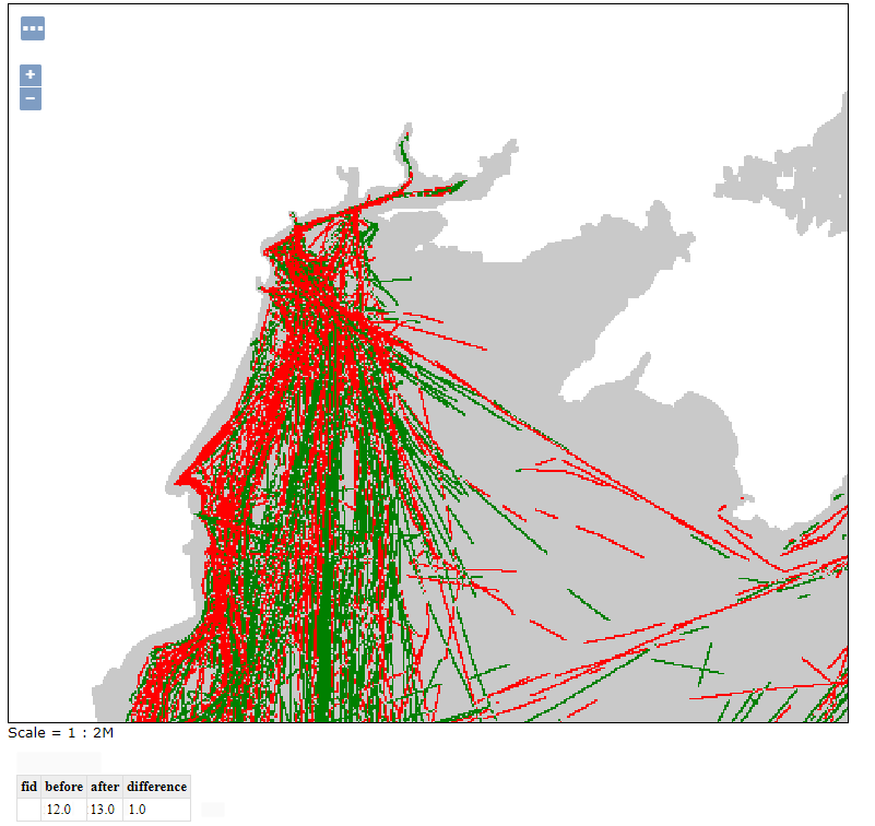
The Jiffle scripting language is used to run raster algebra against one or more input raster layers. In this release we added the ability to generate multi-band outputs, whilst previous versions of Jiffle could generate only single-banded outputs.
Here is an interesting example of how this can be useful. Let’s take an image mosaic with time dimension, and configure its generation mode to “stack”. This will make the mosaic use each image matching the request as an output band. Then, let’s make a WMS request with two times, thus, generating an image with two bands, allowing for a before/after comparison, and use the following style, reporting in output the before, the after, and the difference, using Jiffle as a rendering transformation:
<code><?xml version="1.0" encoding="UTF-8"?>
<StyledLayerDescriptor xmlns="http://www.opengis.net/sld"
 xmlns:ogc="http://www.opengis.net/ogc"
 xmlns:xlink="http://www.w3.org/1999/xlink"
 xmlns:xsi="http://www.w3.org/2001/XMLSchema-instance"
 xsi:schemaLocation="http://www.opengis.net/sld
http://schemas.opengis.net/sld/1.0.0/StyledLayerDescriptor.xsd"
 version="1.0.0">
  <NamedLayer>
    <Name>InputLayer</Name>
    <UserStyle>
      <Title>Time comparison</Title>
      <FeatureTypeStyle>
        <Transformation>
          <ogc:Function name="ras:Jiffle">
            <ogc:Function name="parameter">
              <ogc:Literal>coverage</ogc:Literal>
            </ogc:Function>
            <ogc:Function name="parameter">
              <ogc:Literal>script</ogc:Literal>
              <ogc:Literal>
                before = src[0];
                after = src[1];
                dest[0] = before;
                dest[1] = after;
                dest[2] = after - before;
              </ogc:Literal>
            </ogc:Function>
            <ogc:Function name="parameter">
              <ogc:Literal>bandNames</ogc:Literal>
              <ogc:Literal>before,after,difference</ogc:Literal>
            </ogc:Function>
          </ogc:Function>
        </Transformation>
        <Rule>
          <RasterSymbolizer>
            <Opacity>1.0</Opacity>
            <ChannelSelection>
              <GrayChannel>
                <SourceChannelName>3</SourceChannelName>
              </GrayChannel>
            </ChannelSelection>
            <ColorMap>
              <ColorMapEntry color="#800000" quantity="-1"/>
              <ColorMapEntry color="#008000" quantity="1"/>
            </ColorMap>
          </RasterSymbolizer>
        </Rule>
      </FeatureTypeStyle>
    </UserStyle>
  </NamedLayer>
</StyledLayerDescriptor></code>
The result is a color code map showing red when the change is negative, green where it’s positive. As a bonus, running a GetFeatureInfo on the map would return all 3 values, before, after, and difference.
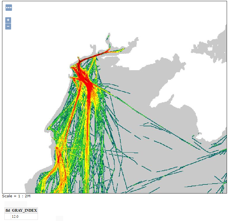
Source maps are also available for reference:
Map projections news
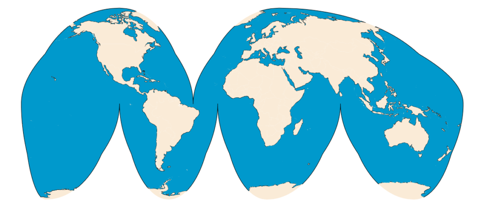
This release comes with support for Goode’s interrupted Homolosine, including both the projection itself, and the advanced projection handling machinery to handle on the fly source data slicing.
This means one can use a common map, like Natural Earth or OSM land masses and seas, and use it without any preparation, obtaining the following:
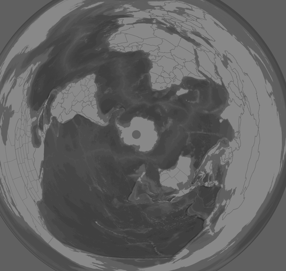
Still in the projections support department, we can cite:
- Support for the Polyconic spherical case
- Improvements in the Azimuthal Equidistant support, with better handling of source slicing when the CRS has false origins.
The following map is a polar Azimuthal Equidistant, with false origins, generated from data originally in web mercator (hence the hole in Antarctica):
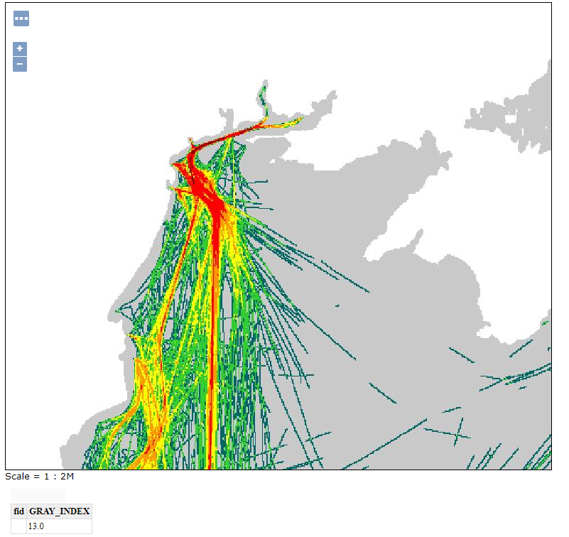
Vector tiles improvements
The vector tiles extension can now work hand-in-hand with the pre-generalized data store, significantly speeding up the generation of MVTs out of a large dataset. A typical example of this case is generating vector tiles out of a OpenStreetMap import performed via imposm3, along with generalized tables.
Map-box GL styles language support improved
MBStyle support continues to improve with support for the dynamic expressions allowing a both feature attributes and “camera” information such as zoom level to be included.
<code>{ "version": 8,
  "name": "landmarks",
  "layers": [
      {   "id": "Expression example",
          "type": "circle",
          "paint": {
              "circle-color": "#dd9933",
              "circle-radius": ["/",["get","LAND"],15],
          }
      }
  ]
}</code>
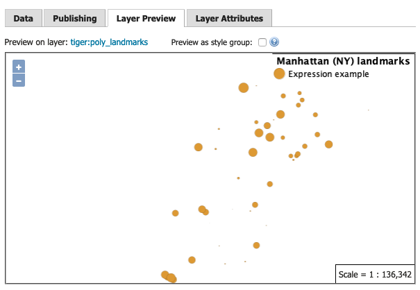 Mapbox Style Expression example
GeoServer continues to support the earlier “function stop” approach for compatibility with the vast majority of examples online.
Community Modules
The GeoServer project devotes space to community research and development activities.
- The GeoPackage community module is having a breakout of creativity with a host of fascinating functionality being added by Andrea Aime (GeoSolutions).
- Dumping a GeoPackage with WPS or WFS output formats is now significantly faster, thanks to insert batching and improved selection of settings/pragma while creating the SQLite database.
- GeoPackage WPS output can now inline linked metadata and add OWS Contexts for request and data, providing full provenance information.
- GeoPackage WPS output can now include styles, based on an experimental style extension along with semantic annotations linking styles to data.
- Activity is ongoing to add a generalized tables extension, similar to the pre-generalized store, but built into the GeoPackage itself.
- A new module looking at attribute labeling has been started by Fernando Miño.
- Fixed an issue with JMS plugin replicating SLD styles
- JDBCStore speed improvement with automatic caching of select directories
- The WPS download module can now preserve the original resolutions when working against heterogeneous CRS mosaic, for the granules that are matching the requested output CRS.
- The GRS module has been made available, adding ArcGIS REST compatibility API.
- The JSON-LD community module has been extended to support custom JSON output too, and renamed to wfs-template.
If you are interested in seeing any of this work included on the GeoServer roadmap contact the developer to learn how to participate or fund the activity.
And more
Other fixes and improvements include:
- LayerGroups now list a default style in the capabilities document for greater client compatibility
- CSW module performance fix when paging output
- Josh Fix introduced a proposal to help determine GridCoverageReader object types to help work with Cloud Optimized GeoTIFF images.
- Importer has been improved with better logging and error messages
- REST API allows changing name and workspace of a data store
- The latest JTS 1.17.1 release
- MetadataLinkInfo allows more metadata types to be edited, including optional about field
- GetFeatureInfo templates can now call static methods, such as Math functions, providing additional control.
- Styled editor now provides a choose image dialog for setting legend image
- PDF output can now include WMS decorations
Find out more in the release notes.
About GeoServer 2.18
Additional information on GeoServer 2.18 series:
GeoServer 2.16.5 Released
We are pleased to announce the release of GeoServer 2.16.5 with downloads (war|zip), documentation and extensions.
This release is made in conjunction with GeoTools 22.5. This is the final planned maintenance release and we highly recommend users to switch to the 2.17 branch for production systems.
Thanks to everyone who contributed, and Ian Turton (Astun Technology) for making this release.
Improvements and Fixes
[GEOS-6467] - UI bug in disabling tile caching for layers
[GEOS-8569] - JSON encoding on NaN values fails
[GEOS-9266] - Geopackage raster table with dots in the name cannot be added
[GEOS-9482] - Nearest Match NPE if source database table is empty
[GEOS-9539] - URLKvpParser encodes urls also when not needed
[GEOS-9622] - NullPointerException when using WMS vendor parameter “CLIP” on an ImageMosaic based layer
[GEOS-9629] - Legend Graphic fails on first visit to publish tab on a new layer publish
[GEOS-9638] - Duplicate SRS in Native SRS List selection on WFS 2.0.0 layer
[GEOS-9639] - Add OGC URN syntax support for Native SRS selection
[GEOS-9649] - NullPointerException for geoJSON output format with ComplexFeatures if some feature misses geometry value
[GEOS-9654] - Layer preview layer count and paging off base when secured layers are not visible
[GEOS-9655] - WMTS layer configuration page doesn’t show all the native srs in getCapabilties document
[GEOS-9668] - UniqueProcess call against a JDBC store does not result in a “select distinct” anymore
[GEOS-9678] - SldService numberFormatException if percentages true with customClasses
[GEOS-9680] - WMTS othersSrs always add EPSG:4326 and shows wrong CRS code
[GEOS-9682] - GetFeatureInfo on raster layers ignores rendering transformations
About GeoServer 2.16
Features, presentations and reference material on the 2.16 series:
- State of GeoServer 2.16 (video|slides)
- GeoServer Feature Frenzy 2019 (video|slides)
- New SLDService extension using data classification for style generation
- New authentication key extension available
- Server status page now includes system status details
- GDAL 2.x binaries are now used for GDAL image formats along with OGR WFS output and WPS output formats
- Release Notes ( 2.16.5 | 2.16.4 | 2.16.3 | 2.16.2 | 2.16.1 | 2.16.0 | 2.16-RC1 )
GeoServer 2.17.2 Released
| We are pleased to announce the release of GeoServer 2.17.2 with downloads (war | zip), documentation and extensions. |
This release is made in conjunction with GeoTools 23.2 and GeoWebCache 1.17.2. This is a stable release recommended for production systems.
Thanks to everyone who contributed, and Jody Garnett (GeoCat) for making this release. Additional thanks to everyone who participated in the July bug-fix sprint organized by GeoSolutions.
Improvements and Fixes
This release includes a number of improvements, including:
- GetFeatureInfo templates can now be used for GeoJSON output
- The WPS download community module can now generate elevation models accounting for vertical grid shift when changing datum.
- Oracle extension now ready to use with included JDBC driver, the driver changed to a “Oracle Free Use Terms and Conditions” license allowing us to distribute.
- PostreSQL driver, Oracle driver, Eclipse EMF library, spring-framework, and spring-security version updates.
- Image Mosaic REST API can now be used to update the native bbox when harvesting or deleting granules
Fixes included in this release:
- GetFeatureInfo fixed to work on raster layer dynamically produced by a rendering transformation.
- Lots of WMTS fixes resolving SRS list duplicates and handling of otherSrs.
- SLD Service handling of percentages with custom classes
- Layer preview fix, was miscounting number of pages when security restrictions used to limit number of layers available
- Binary download on windows fixed to autodect Java when spaces used in path
- WFS Cascade fixed to remove duplicate SRS elements when connecting to WFS 2.0.0 layer
- MongoDB extension fixed, was missing a jar
- Database use of select distinct in the WPS Unique process fixed
- Image mosaic fixes for WPS download process bbox generation, and WMS GetMap respect of CLIP vendor parameter,
- GeoPackage supports raster tables with special characters
For more information check the 2.17.2 release notes.
Community Updates
For developers building from source, our community modules are a great place to collaborate on functionality and improvements.
- The JSON-LD module is under active development with templating now supporting filtering, environmental variable substitution. Thanks to the sponsorship of the French geological survey – BRGM and the French environmental information systems research center – INSIDE.
- The GSR community module working on packaging, addressed a startup problem.
About GeoServer 2.17
Features, presentations and reference material on the 2.17 series:
- New security tab on each layer, layer group and workspace page
- Option to use date created and date modified to sort UI lists
- New resource browser extension
- New Mapbox style extension
-
FOSDEM GeoServer Orientation presentation (slides video) - Full OSM data directory for GeoServer available on GitHub
- Code of Conduct
-
Release Notes (2.17.2 2.17.1 2.17.0 2.17-RC)
GeoServer 2.16.4 released
| We are pleased to announce the release of GeoServer 2.16.4 with downloads (war | zip), HTML documentation and extensions. |
This is a stable release recommended for production systems.
Improvements and Fixes
This release includes a number of improvements, including:
- The GetFeatureInfo GeoJSON output can now be controlled with freemarker templates.
- Image mosaic REST API now allows updating the native BBOX of the mosaic during update and delete operations. It’s also now possible to store the mosaic index in SQL Server.
- Documentation on how to integrate the app-schema plugin with MongoDB has been improved.
- The JSON-LD community module has a new option to filter output contents.
- The WPS download community module can reproject the eventual pixel value as well, in case it is an elevation, using a grid shift file.
For more information and the small assorted bug fixes, check the 2.16.4 release notes.
About GeoServer 2.16
Features, presentations and reference material on the 2.16 series:
- State of GeoServer 2.16 (video|slides)
- GeoServer Feature Frenzy 2019 (video|slides)
- New SLDService extension using data classification for style generation
- New authentication key extension available
- Server status page now includes system status details
- GDAL 2.x binaries are now used for GDAL image formats along with OGR WFS output and WPS output formats
- Release Notes ( 2.16.4 | 2.16.3 | 2.16.2 | 2.16.1 | 2.16.0 | 2.16-RC1 )
GeoServer 2.17.1 Released
| We are pleased to announce the release of GeoServer 2.17.1 with downloads (war | zip), documentation and extensions. |
This release is made in conjunction with GeoTools 23.1 and GeoWebCache 1.17.1. This is a stable release recommended for production systems.
Thanks to everyone who contributed, and Jody Garnett (GeoCat) for making this release. Additional thanks to Jukka, Charles, Jody and Graham for helping test on the GeoServer user list. Testing in a wide range of environments is important for the community, and we appreciate seeing more people involved.
Improvements and Fixes
This release includes a number of improvements, including:
- SLD Service Extension now supports percentages when generating rule titles, or individual colormap entries
- SLD Service generation fix to avoid duplicating classes in generated style
Fixes included in this release:
- WMS Legend decoration fix to correct image size calculation, and to display legend for raster layers
- Fix WPS DownloadMap process to support use of WMS Legend decoration
- Fix for vector tile generation, taking into account line width to prevent gaps between tiles
For more information check the 2.17.1 release notes.
Community Updates
For developers building from source, our community modules are a great place to collaborate on functionality and improvements.
- A GSR community module is now available providing an GeoService REST compatibility API.
- Backup restore development continues, with an option to exclude select content during restore
- We have removed all references to the spatialite datastore from our documentation as this extension has not been produced for some time. Those wishing to work with spatialite can do so via the ogr datastore.
About GeoServer 2.17
Features, presentations and reference material on the 2.17 series:
- New security tab on each layer, layer group and workspace page
- Option to use date created and date modified to sort UI lists
- New resource browser extension
- New Mapbox style extension
-
FOSDEM GeoServer Orientation presentation (slides video) - Full OSM data directory for GeoServer available on GitHub
- Code of Conduct
-
Release Notes (2.17.1 2.17.0)