GeoServer Blog
GeoServer 2.10.5 Released
We are pleased to announce the release of GeoServer 2.10.5. Downloads are available (zip, war, dmg and exe) along with documentation and extensions.
This release is made by Ian Turton and is the final maintenance release of the 2.10 series, you are encouraged to upgrade at this time.
About GeoServer 2.10
Articles, docs, blog posts and presentations:
-
The YSLD extension added, with extensive documentation (user guide)
-
State of GeoServer 2016 (slideshare)
-
The style editor has been refreshed with the best ideas from the css extension (user guide)
-
The styling workshop has been updated for foss4g 2016 and now includes both CSS and YSLD examples (user guide)
-
Smart transparency in GeoServer with image/vnd.jpeg-png format (GeoSolutions)
-
QGIS SLD export improvements (GeoSolutions)
Community modules
-
A new community module to backup/restore and restore GeoServer configuration
-
A resource browser is available allowing remote management of styles, icons and fonts (needs building from sources).
-
A new WMTS multidimensional domain discovery community module for discovering patches of data in scattered data sets
GeoServer 2.11.2 released
We are happy to announce the release of GeoServer 2.11.2. Downloads are available (zip, war, dmg and exe) along with documentation and extensions.
GeoServer 2.11.1 is the latest stable release of GeoSever recommended for production system. This release is made in conjunction with GeoTools 17.1.
| Highlights of this release are featured below, for more information please see the release notes (2.11.2 | 2.11.1 | 2.11.0 | 2.11-RC1 | 2.11-beta ). |
New Features and Improvements
-
There is a new GetLegendGraphic option that will return feature counts in the legend label, counting them in the current bounding box
-
Geometries in GetFeatureInfo GML output are now reprojected following the base GetMap output projection
-
The LayerGroup edit page allows configuring keywords and identifiers (as already available for normal layers)
Bug Fixes
-
Various raster improvements, including better handling of heterogeneous CRS mosaics, lower pixelation at high latitudes in EPSG:3857,
-
GetLegendGraphic against multiple layers did not work if any layer was out of scale range, fixed
-
GetFeatureInfo now works against a mix of queriable and non queriable layers
-
Cascading WMS now supports very long credentials
-
Several fixes and tweaks in the configuration UI for an improved experience
-
And several more, check the release notes for full details
About GeoServer 2.11
Articles, docs, blog posts and presentations:
-
OAuth2 for GeoServer (GeoSolutions)
-
YSLD has graduated and is now available for download as a supported extension
-
Vector tiles has graduate and is now available for download as an extension
-
The rendering engine continues to improve with underlying labels now available as a vendor option
-
A new “opaque container” layer group mode can be used to publish a basemap while completely restricting access to the individual layers.
-
Layer group security restrictions are now available
-
Latest in performance optimizations in GeoServer (GeoSolutions)
-
Improved lookup of EPSG codes allows GeoServer to automatically match EPSG codes making shapefiles easier to import into a database (or publish individually).
GeoServer 2.10.4 Released
We are pleased to announce the release of GeoServer 2.10.4. Downloads are available (zip, war, dmg and exe) along with documentation and extensions.
This is a maintenance release of GeoServer suitable for production systems. Maintenance releases are focused on bug fixes and stability, rather than new features. This release is made in conjunction with GeoTools 16.4 and GeoWebCache 1.10.3.
This release is made by Torben Barsballe and Kevin Smith from the Boundless team. Special thanks to Nick Stires from Boundless and the Frank Warmerdam from OSGeo for their help setting up the new build.geoserver.org server used for this release. We would like to thank these volunteers and everyone who contributed features, fixes and time during the release process.
Security Considerations
The 2.10.3 release addressed three security vulnerabilities. Details of these vulnerabilities were not included in the 2.10.3 blog post to provide time for the fixes to be included in 2.11.1, and have been replicated here:
-
Added a configurable delay during login, to mitigate a brute force attack.
-
Added a configurable parameter to control clickjacking attacks against the GeoServer UI.
-
Added an additional parameter for locking down password autocomplete in the GeoServer UI
Thanks to Andrea Aime and Devon Tucker for providing fixes to these issues.
If you wish to report a security vulnerability, please visit our website for instructions on responsible reporting.
New Features and Improvements
-
Add rest endpoint for geofence admin rules
-
Add REST endpoint for a user to change their password
-
Allow disabling usage of SLD and SLD_BODY in WMS requests (also for virtual services)
Bug Fixes
-
Native JAI installation instructions report incorrect information about the installers
-
Downloading zip file using /rest/workspaces/
/datastores/ /file.shp doesn't work after GeoServer reload -
Virtual services do not play nice with GML 3 encoding
-
Namespace filtering on capabilties returns all layer groups (including the ones in other workspaces)
-
Cascaded WMS does not encrypt configuration password
-
Reloading GeoServer re-enables all disabled WMTS services
-
Slow WFS GetFeature when using a 3D bbox POST request
-
WMS cascading fails with NPE when advanced projection handling gets disabled
-
Style Editor Preview Legend Fails on non-SLD Styles
-
Exception when saving a layer group in GeoServer UI
-
JMS fails to handle styles workspaces changes
-
WFS-T Insert FeatureIds being returned in incorrect order
-
CSW get capabilities ingore virtual services settings and always use the global service ones
-
Integrated GWC does not work with layer and layer group specific services
| And more! For more information on this release check the release notes ( 2.10.4 | 2.10.3 | 2.10.2 | 2.10.1 | 2.10.0 | 2.10-RC1 | 2.10-beta | 2.10-M0 ) |
About GeoServer 2.10
Articles, docs, blog posts and presentations:
-
The YSLD extension added, with extensive documentation (user guide)
-
State of GeoServer 2016 (slideshare)
-
The style editor has been refreshed with the best ideas from the css extension (user guide)
-
The styling workshop has been updated for foss4g 2016 and now includes both CSS and YSLD examples (user guide)
-
Smart transparency in GeoServer with image/vnd.jpeg-png format (GeoSolutions)
-
QGIS SLD export improvements (GeoSolutions)
Community modules
-
A new community module to backup/restore and restore GeoServer configuration
-
A resource browser is available allowing remote management of styles, icons and fonts (needs building from sources).
-
A new WMTS multidimensional domain discovery community module for discovering patches of data in scattered data sets
GeoServer at FOSS4G 2017 Boston
The annual “Free and Open Source Software for Geospatial” conference is coming to Boston on August 14-19.
This is the global meeting-of-the-tribes event for the spatial community, held by the Open Source Geospatial Foundation. Going well beyond just an event, FOSS4G features hands-on workshops, exciting presentation, technical presentations, exciting technical presentations … along with informal bird-of-a-feather gatherings, a code sprint, and social events.
The GeoServer project is proudly represented at FOSS4G with presentations from the core GeoServer team and success stories from happy users worldwide.
Workshops
The conference opens with two days of workshops. FOSS4G workshops are a great way to access hands-on training with GeoServer, provided by core members of the development team. You are sure to learn something new.
GeoServer workshops:
-
OGC Services in Action: an introduction with GeoServer: Join Andrea Aime from GeoSolutions for this popular course. Covering OGC services, setting up vector and raster data, along with viewing and styling data.
-
GeoServer & PostGIS in Containers and On Kubernetes: Steve Pousty from Red Hat provides an introduction to Docker containers and Kubernetes using the popular combo of PostGIS and GeoServer.
-
Enterprise class deployment for GeoServer and GeoWebcache: optimizing performances and availability: Simone Giannecchini and Andrea Aime from GeoSolutions are back with hands on experience guiding you through the performance, availability and optimization of GeoServer and GeoWebCache.
GeoTools workshops:
-
**Introduction to GeoTools: **Ian and Jody offer an introduction for Java developers.
-
GeoTools DataStore Workshop: Teach GeoServer a new format with this java development workshop.

Presentations
The conference features three days of presentations (with some great keynotes to look forward to from Dr. Richard Stallman, Paul Ramsey and others). GeoServer is well represented with a great selection of talks to choose from.
Core contributors to GeoServer have the following talks:
-
State of GeoServer: Update of everything new and improved for 2017 brought to you by the project team.
-
GeoServer Feature Frenzy: A feature based tour of what GeoServer has to offer, brought to you by the project team.
-
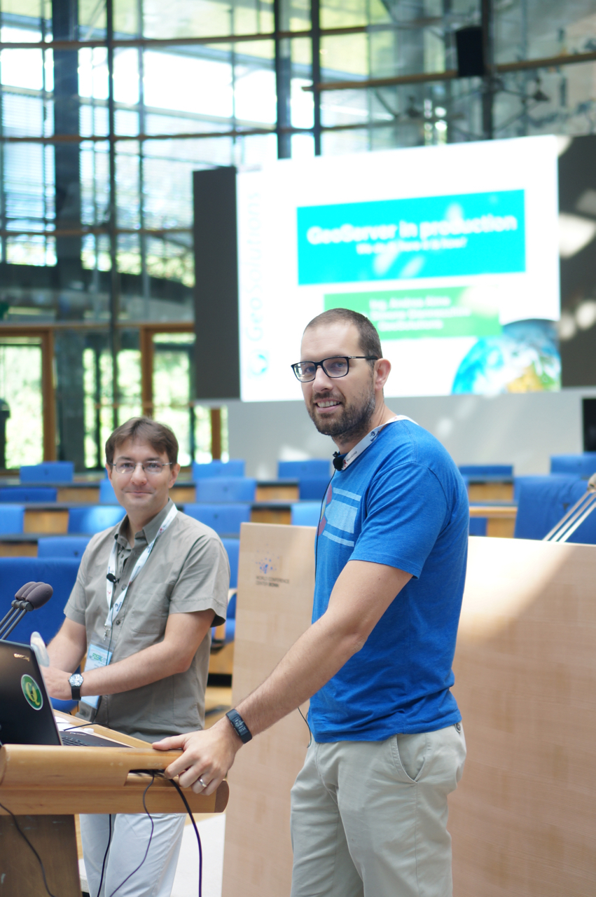
GeoServer in Production: we do it, here is how! Simone and Andrea share battle hardened advice for production installations.
-
**MapBox Styles for GeoServer and OpenLayers: **Torben and David introduce native MapBox styles support, allowing shared client and server styling for a consistent visual presentation.
-
Mapping the world: going beyond web mercator with GeoServer: Andrea provides insight into the creativity available with GeoServer.
-
State of GeoWebCache: Kevin Smith explores tile protocols and the advantages they bring to your GeoServer deployment.
-
Creating Stunning Maps in GeoServer : mastering SLD and CSS styles: GeoServer is host to a powerful rendering engine, unlock your creativity with this introduction to the human-readable cascading style sheet cartography.
The wider GeoServer community is will represented in the rest of the program.
-
Development of an extension of GeoServer to provide handling three-dimensional spatial data: Pusan National Univeristy is back with an research and development area for GeoServer, use of 3D data for indoor mapping.
-
GeoServer Clustering Revisited: Getting Your Docker On
-
Monsanto & Boundless contribution to the open source community; enabling fine grain entitlement for open source geospatial cloud systems (GeoServer) and desktop applications (QGIS)
Many more talks feature GeoServer as part of a successful open source solution. During the abstract submission process GeoServer was the most cited software component.
Bird of a Feather Session
A highlight of FOSS4G is the community aspect of meeting with GeoServer enthusiasts from all backgrounds. We will schedule an evening bird-of-a-feather session for GeoServer Q&A.
Bring your questions, your stories and perhaps a map to share!

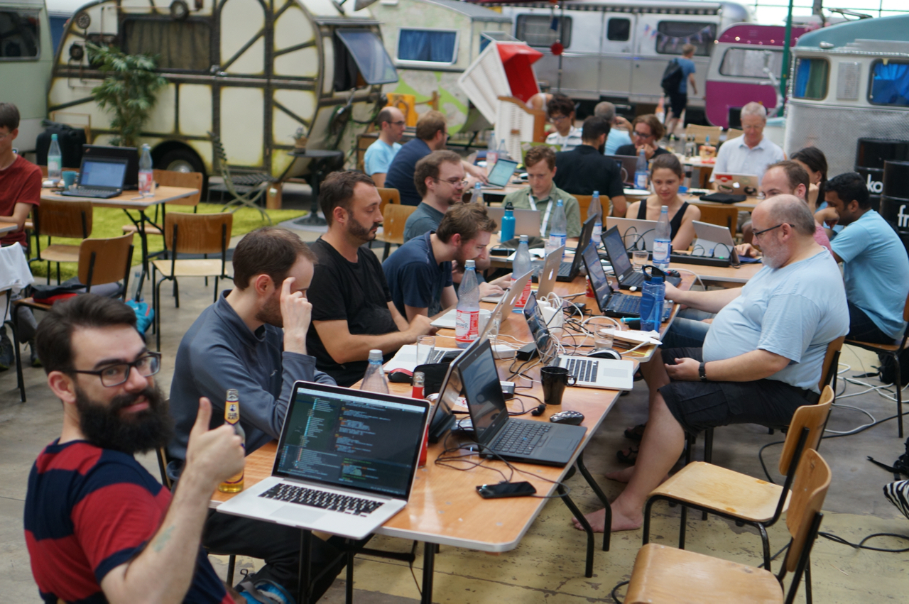
Code Sprint
An OSGeo code-sprint is held after the conference offering volunteers a chance to work on the codebase. If you are new to our community please consider attending, we will have a selection of activities ready to go for all skill levels.
Sign up on the OSGeo Wiki, and add your ideas and suggestions.
This is a great opportunity to contribute to the project, please be advised that it is a work party (so bring your own laptop, caffeine will be provided).
See you at FOSS4G Boston
If you would like to join GeoServer in Boston registration is open, $800 for the 3 day conference. Workshops are $125-$350 depending on how many you attend. There is also a great volunteer program (2 hours of training, and 12 work for a $50 registration).
Attending FOSS4G is strongly recommended. While there are friendly regional foss4g conferences nothing compares to the momentum and enthusiasm of the global event.
Thanks to all the presenters and instructors for the GeoServer advocacy, this will be a great event.

GeoServer 2.11.1 Released
We are happy to announce the release of GeoServer 2.11.1. Downloads are available (zip, war, dmg and exe) along with documentation and extensions.
GeoServer 2.11.1 is the latest stable release of GeoSever recommended for production system. This release is made in conjunction with GeoTools 17.1.
| Highlights of this release are featured below, for more information please see the release notes (2.11.1 | 2.11.0 | 2.11-RC1 | 2.11-beta ). |
Security Considerations
This release addresses three security vulnerabilities:
-
Added a configurable delay during login, to mitigate a brute force attack.
-
Added a configurable parameter to control clickjacking attacks against the GeoServer UI.
-
Added an additional parameter for locking down password autocomplete in the GeoServer UI
Thanks to Andrea Aime and Devon Tucker for providing fixes to these issues.
These fixes are also included in the 2.10.3 release.
If you wish to report a security vulnerability, please visit our website for instructions on responsible reporting.
New Features and Improvements
-
There is a new Mapbox Style community module available, which adds support for an interoperable json styling language. For more details, refer to the documentation.
-
GSIP 158 - NetCDF output support for variable attributes and extra variables. This improvement adds the ability to set attributes on output NetCDF variables, copy attributes from source NetCDF/GRIB variables, and copy scalar variables from NetCDF/GRIB sources including ImageMosaics. See the documentation for details.
-
Allow disabling usage of SLD and SLD_BODY in WMS requests (also for virtual services).
Bug Fixes
-
Various improvements to virtual services, including lookup and GML 3 encoding handling
-
Namespace filtering on capabilities returns all layer groups (including the ones in other workspaces)
-
Not possible to PUT workspace using REST
-
GeoServer Home Page missing information messages
-
Style Editor Preview Legend Fails on non-SLD Styles
-
Integrated GWC does not work with layer and layer group specific services
-
Generating a raster SLD style from template produces a functionally invalid style
-
GeoServer generates invalid GeoPackage raster mosaics
-
Metatiling may throw a ClassCastException: Raster cannot be cast to WritableRaster
About GeoServer 2.11
Articles, docs, blog posts and presentations:
-
OAuth2 for GeoServer (GeoSolutions)
-
YSLD has graduated and is now available for download as a supported extension
-
Vector tiles has graduate and is now available for download as an extension
-
The rendering engine continues to improve with underlying labels now available as a vendor option
-
A new “opaque container” layer group mode can be used to publish a basemap while completely restricting access to the individual layers.
-
Layer group security restrictions are now available
-
Latest in performance optimizations in GeoServer (GeoSolutions)
-
Improved lookup of EPSG codes allows GeoServer to automatically match EPSG codes making shapefiles easier to import into a database (or publish individually).
Behind The Scenes
- GeoServer 3 First public release date
- GeoServer 3 Sprint Update
- GeoServer 2025 Q4 Developer Update
- GeoServer 3 Crowdfunding Goal Surpassed!
- GeoServer 2025 Q2 Developer Update
- GeoServer 3 Crowdfunding – Last Call!
- GeoServer 3 Crowdfunding Campaign Reaches Major Step: 80% Funding Completion
- GeoServer 2025 Roadmap
- GeoServer 2024 Q4 Developer Update
- GeoServer 3 Call for Crowdfunding