GeoServer Blog
GeoServer 2.4.4 Released
The GeoServer team is pleased to announce the release of GeoServer 2.4.4:
This is a stable release containing bug fixes and incremental improvements, including:
-
Role service implementation based on LDAP
-
CSV output for app-schema simple features level zero
-
WPS GeoTiff tiling improvements
-
Layer rendering robustness issues relating to mis specified fonts
-
Fixes to Symbology Encoding Halo parsing
-
And more! Checkout of the change log for the full list
Thanks to all those who contributed fixes, and documentation corrections, for this release. This release is made in conjunction with GeoTools 10.4.
Spot a translation mistake? Help translate here: GeoServer Stable localization
About the GeoServer 2.4 series
The following change control requests were completed during the development of GeoServer 2.4:
-
Replace old KML module with new one (GSIP 98)
-
Allow plugins to modify WMS MapContent before map rendering (GSIP 92)
-
Machinery to pass thread locals down in thread pools (GSIP 96, fixes WPS asych requests security issues) - also available in 2.3.4
-
Promote CSS Styling module from Community to Extension (GSIP 97) - also available in 2.3.2
-
Graduate the INSPIRE module to extension status (GSIP 94) - also available in 2.3.2
-
Promote XSLT community module to extension (GSIP 93) - also available in 2.3.1
-
The shapefile datastore was completely rewritten (mostly as a code cleanup)
Articles and blogs during GeoServer 2.4 development:
-
GeoServer FOSS4G 2013 (State of GeoServer, Introduction, Steroids, GeoFence, RasterData, Spatio-Temporal, Cartographic Rendering)
-
How to publish GDAL/MrSID image formats on a production GeoServer
-
FOSS4G-NA slides (GeoServer In Production, GeoServer CSS Module, Scripting GeoServer with GeoScript, The State of GeoServer 2013)
-
INSPIRE Conference 2013 slides (Analysing GeoServer compatibility with INSPIRE requirements)
-
FOSSGIS 2013 slides (Introduction to GeoServer)
Using GeoServer at IGN (the French National Mapping Agency) to create new digital maps
We start the new year with a report of how IGN uses GeoServer to deliver high quality maps. We’d like to thank in advance the IGN team for the very nice showcase, and we leave you to their report.
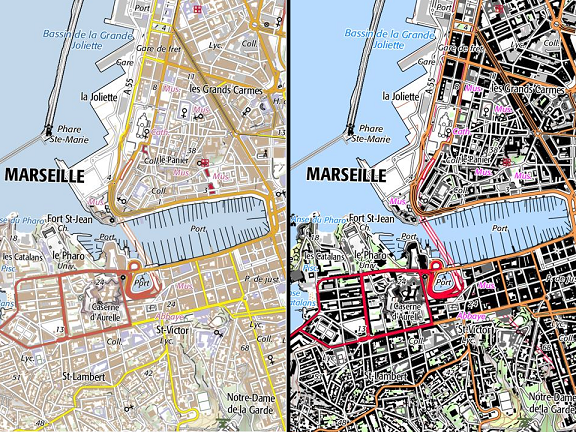
Thanks to GeoServer and other technologies, IGN France is now able to provide new digital maps to professional users. These maps, named “SCAN Express”, cover the French territory, and are fully updated every six months. Two kinds of map with two different color charts are available through the French Géoportail WMS and WMTS services (http://api.ign.fr ), offering an advanced cartographic map rendering of IGN’s topographic databases.
Here are some screenshots, with different zoom levels:


One color chart (the “standard legend”) offers pastel colors, so that user data can be added to the map, and keep it readable. The other one (the “classical legend”) is similar to well-established legends of IGN’s paper maps.
First, data are processed using different softwares and libraries depending on scale (open-source, proprietary or home-made) performing automatic tasks such as generalization or high-level cartographic label placement. Thus, 1Spatial software or JTS library are used. Then, cartographers perform controls using desktop GIS such as OpenJump or GeoConcept. Data are stored in PostgreSQL/PostGIS databases.
Rendering is fully based on GeoServer capabilities. More than 300 SLD files defining almost 2000 feature styles have been written to manage rendering with smooth transitions at 12 different zoom levels. In order to allow map legend customization, the “variable substitution in SLD” mechanism is used to compute easily different kind of color charts according to needs (about 50 variables allowing a wide range of customization possibilities).This could open the way to new web services that will allow dynamic customization of this cartographic background.
Raster tiles are produced by sending GeoServer WMS requests, whose resolution depends on the map scale, from 0.5 to 2048 meters per pixel. Requests are load-balanced on several GeoServe instances, to produce more than 500 Gb of data per color chart.
GeoServer is well suited to IGN’s need and its efficiency is much appreciated. IGN’s team focusing on these topics wishes to point out that the cartographic rendering capabilities of GeoServer are very rich and can be exploited in an industrial context.
GeoServer 2.4.3 Released
The GeoServer team is pleased to announce the release of GeoServer 2.4.2:
This is a stable release containing bug fixes and incremental improvements, including:
-
A great performance improvement for those using sql views
-
Fix for defining a workspace style using CSS extension
-
Workspace styles can now manage their own images and graphics
-
Thanks to all those who contributed fixes, and documentation corrections, for this release.
This release is made in conjunction with GeoTools 10.3.
Spot a translation mistake? Help translate here: GeoServer Stable localisation
About the GeoServer 2.4 series
The following change control requests were completed during the development of GeoServer 2.4:
-
Replace old KML module with new one (GSIP 98)
-
Allow plugins to modify WMS MapContent before map rendering (GSIP 92)
-
Machinery to pass thread locals down in thread pools (GSIP 96, fixes WPS asych requests security issues) - also available in 2.3.4
-
Promote CSS Styling module from Community to Extension (GSIP 97) - also available in 2.3.2
-
Graduate the INSPIRE module to extension status (GSIP 94) - also available in 2.3.2
-
Promote XSLT community module to extension (GSIP 93) - also available in 2.3.1
-
The shapefile datastore was completely rewritten (mostly as a code cleanup)
Articles and blogs during GeoServer 2.4 development:
-
GeoServer FOSS4G 2013 (State of GeoServer, Introduction, Steroids, GeoFence, RasterData, Spatio-Temporal, Cartographic Rendering)
-
How to publish GDAL/MrSID image formats on a production GeoServer
-
FOSS4G-NA slides (GeoServer In Production, GeoServer CSS Module, Scripting GeoServer with GeoScript, The State of GeoServer 2013)
-
INSPIRE Conference 2013 slides (Analysing GeoServer compatibility with INSPIRE requirements)
-
FOSSGIS 2013 slides (Introduction to GeoServer)
GeoServer Online Code Sprint this Friday!

The GeoServer community is planning an online code sprint this Friday to fix bugs and improve documentation. Join us in #geoserver on Freenode and let’s see how productive we can be. To help coordinate efforts, Andrea Aime is has prepared a list of bugs on Jira to kick start the sprint.
Regards,
GeoServer Team
GeoServer 2.4.2 released
The GeoServer team is pleased to announce the release of GeoServer 2.4.2:
This is a stable release containing bug fixes and incremental improvements, including:
-
Total matched feature count available in JSON output (contributed by Paul Biskup)
-
Ability to control how scale hints are computed in WMS 1.1 (contributed by Roy Braam and Mauricio Pazos)
-
Support for randomized symbol fills in both SLD and CSS (thanks to New South Wales Geological survey for sponsoring it)
-
Better support for data with 3D coordinates using GML3/GeoJSON, and associated improvements in the SQL Server backend (thanks to IGEA, Croatia, for sponsoring this work)
-
WCS 1.0 can be disabled
-
Several translation updates and improvements, thanks to the translation team. In no particular order: Polish, Korean, German, Lithuanian, Spanish, Romanian, French
-
Several small fixes in the docs (thanks to all the good people that contributed them!)
This release is made in conjunction with GeoTools 10.2.
Spot a translation mistake? Help translate here: GeoServer Stable localisation
About the GeoServer 2.4 series
The following change control requests were completed during the development of GeoServer 2.4:
-
Replace old KML module with new one (GSIP 98)
-
Allow plugins to modify WMS MapContent before map rendering (GSIP 92)
-
Machinery to pass thread locals down in thread pools (GSIP 96, fixes WPS asych requests security issues) - also available in 2.3.4
-
Promote CSS Styling module from Community to Extension (GSIP 97) - also available in 2.3.2
-
Graduate the INSPIRE module to extension status (GSIP 94) - also available in 2.3.2
-
Promote XSLT community module to extension (GSIP 93) - also available in 2.3.1
-
The shapefile datastore was completely rewritten (mostly as a code cleanup)
Articles and blogs during GeoServer 2.4 development:
-
GeoServer FOSS4G 2013 (State of GeoServer, Introduction, Steroids, GeoFence, RasterData, Spatio-Temporal, Cartographic Rendering )
-
How to publish GDAL/MrSID image formats on a production GeoServer
-
FOSS4G-NA slides (GeoServer In Production, GeoServer CSS Module, Scripting GeoServer with GeoScript, The State of GeoServer 2013)
-
INSPIRE Conference 2013 slides (Analysing GeoServer compatibility with INSPIRE requirements)
-
FOSSGIS 2013 slides (Introduction to GeoServer)
Behind The Scenes
- GeoServer 3 First public release date
- GeoServer 3 Sprint Update
- GeoServer 2025 Q4 Developer Update
- GeoServer 3 Crowdfunding Goal Surpassed!
- GeoServer 2025 Q2 Developer Update
- GeoServer 3 Crowdfunding – Last Call!
- GeoServer 3 Crowdfunding Campaign Reaches Major Step: 80% Funding Completion
- GeoServer 2025 Roadmap
- GeoServer 2024 Q4 Developer Update
- GeoServer 3 Call for Crowdfunding